IMAGES TAKEN NEAR TO
Shield Hall Lane, SOWERBY BRIDGE, HX6 1NJ
Introduction
This page details the photographs taken nearby to Shield Hall Lane, HX6 1NJ by members of the Geograph project.
The Geograph project started in 2005 with the aim of publishing, organising and preserving representative images for every square kilometre of Great Britain, Ireland and the Isle of Man.

There are currently over 7.5m images from over14,400 individuals and you can help contribute to the project by visiting https://www.geograph.org.uk
Image Map
Images are licensed for reuse under creativecommons.org/licenses/by-sa/2.0
Notes
- Clicking on the map will re-center to the selected point.
- The higher the marker number, the further away the image location is from the centre of the postcode.
Image Listing (51 Images Found)
Images are licensed for reuse under creativecommons.org/licenses/by-sa/2.0
Image
Details
Distance
1
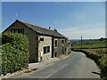
Miry Wall Barn, Shield Hall Lane
A converted barn.
Image: © Stephen Craven
Taken: 24 Apr 2021
0.01 miles
3
Footpath off Shield Hall Lane
This goes to Higham and Dob lane via Snape Wood (which is the house in the distance according to the 1893 1:2500 map).
Image: © Humphrey Bolton
Taken: 14 Feb 2013
0.02 miles
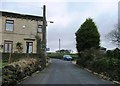
4
Glen View, Shield Hall Lane
This terrace of four houses appeared on the 1907 1:2500 map; the 1893 edition showed a single house at the left end. The building on the right is an old farm, shown on the 1850 map, called Mirey Wall.
Image: © Humphrey Bolton
Taken: 14 Feb 2013
0.02 miles
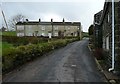
5
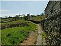
Causewayed footpath off Shield Hall Lane
The path leads to Snape Wood farm and Higham and Dob Lane. The name of the houses to the right (Miry Wall), and reeds to the left, should give an indication of why the path needed to be paved.
Image: © Stephen Craven
Taken: 24 Apr 2021
0.03 miles
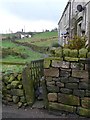
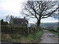
6

Track to Hey End Farm
The farm itself is not visible in this photo, being over the brow of the hill; the pair of houses alongside the track may have been built for farm workers.
Image: © Stephen Craven
Taken: 24 Apr 2021
0.03 miles
8
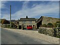
Shield Hall
The 17th century farmhouse and its barn are together listed grade II (list entry 1185404). When listed in 1988 it was in use as a bakery, although that appears no longer to be the case.
Image: © Stephen Craven
Taken: 24 Apr 2021
0.11 miles
9
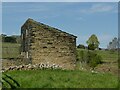
Outbuilding at Shield Hall
This is obviously not the '2-bay barn with King post truss' described in the listing, and is probably just a store of some kind.
Image: © Stephen Craven
Taken: 24 Apr 2021
0.12 miles
10
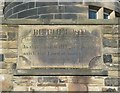
Plaque from old Methodist Chapel, Boulder Clough, Sowerby
This records the first building of 1822. Part of one of the staircase towers of the 1897 building can be seen behind.
Image: © Humphrey Bolton
Taken: 8 Oct 2008
0.12 miles