IMAGES TAKEN NEAR TO
Castle Hill, SOWERBY BRIDGE, HX6 1JD
Introduction
This page details the photographs taken nearby to Castle Hill, HX6 1JD by members of the Geograph project.
The Geograph project started in 2005 with the aim of publishing, organising and preserving representative images for every square kilometre of Great Britain, Ireland and the Isle of Man.

There are currently over 7.5m images from over14,400 individuals and you can help contribute to the project by visiting https://www.geograph.org.uk
Image Map
Images are licensed for reuse under creativecommons.org/licenses/by-sa/2.0
Notes
- Clicking on the map will re-center to the selected point.
- The higher the marker number, the further away the image location is from the centre of the postcode.
Image Listing (162 Images Found)
Images are licensed for reuse under creativecommons.org/licenses/by-sa/2.0
Image
Details
Distance
1
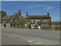
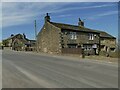
Castle Hill (property), Towngate, Sowerby
Sowerby developed as a village in the 17th century although its origins go back much further than that. The house facing us in this photo, known merely as 52-54 Towngate (having been divided into to properties) dates from 1662 and is grade II* listed (entry 1319946). The house to the left, named Castle Hill after the nearby motte, is grade II (entry 1134460) and is mid-17th century with some earlier elements.
Image: © Stephen Craven
Taken: 24 Apr 2021
0.01 miles
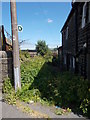
3
Castle Hill, Sowerby
Prepare to be underwhelmed if visiting what is shown on some maps as "Sowerby Castle". The significance of what is now no more than a low circular mound in a cattle field - to the right of and beyond the wall end in this photo - lies rather in its archaeological interest. The listing for this scheduled monument (entry 1016946) describes the site as "A rare surviving example of this type of monument in West Yorkshire. The site retains important archaeological and environmental deposits particularly in the matrix of the castle mound, in the fill of the ditches and on the old land surface buried beneath the mound." The castle that was built on the motte belonged to the Earls of Warren, and dates from some time before 1309. Unusually, this motte had no bailey.
Image: © Stephen Craven
Taken: 24 Apr 2021
0.02 miles
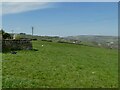
4
Castle Hill Motte remains
This motte has little height preserved
Image: © Kevin Waterhouse
Taken: 26 Sep 2020
0.02 miles
5
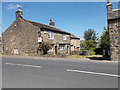
The Royd, Stocks Lane, Sowerby
Sowerby developed as a village in the 17th century although its origins go back much further than that. This house, now subdivided, is one of several listed properties of that period (grade II, entry 1116447) and dates from 1632.
Image: © Stephen Craven
Taken: 24 Apr 2021
0.02 miles
6
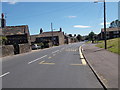
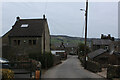
Town Gate - viewed from Rooley Lane
Image: © Betty Longbottom
Taken: 30 Jun 2015
0.02 miles
8
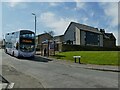
Bus terminus, Rooley Heights, Sowerby
Route 579 from Halifax serves several remote settlements on its way to Sowerby.
Image: © Stephen Craven
Taken: 24 Apr 2021
0.03 miles
9
Descending Rooley Lane
Scene in the village of Sowerby
Image: © Chris Heaton
Taken: 4 Mar 2023
0.04 miles
10
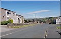
Rooley Heights - looking towards Town Gate
Image: © Betty Longbottom
Taken: 30 Jun 2015
0.05 miles