IMAGES TAKEN NEAR TO
Stainland Road, HALIFAX, HX4 9AJ
Introduction
This page details the photographs taken nearby to Stainland Road, HX4 9AJ by members of the Geograph project.
The Geograph project started in 2005 with the aim of publishing, organising and preserving representative images for every square kilometre of Great Britain, Ireland and the Isle of Man.

There are currently over 7.5m images from over14,400 individuals and you can help contribute to the project by visiting https://www.geograph.org.uk
Image Map
Images are licensed for reuse under creativecommons.org/licenses/by-sa/2.0
Notes
- Clicking on the map will re-center to the selected point.
- The higher the marker number, the further away the image location is from the centre of the postcode.
Image Listing (130 Images Found)
Images are licensed for reuse under creativecommons.org/licenses/by-sa/2.0
Image
Details
Distance
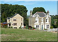
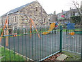
1
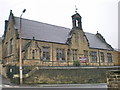
Stainland & Holywell Green URC - Stainland Road
Image: © Betty Longbottom
Taken: 21 May 2008
0.01 miles
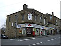
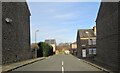
2
Stainland Road, Holywell Green (B6112)
Heading north.
Image: © JThomas
Taken: 14 Mar 2015
0.02 miles
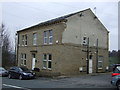
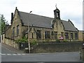
3
Stainland and Holywell Green United Reformed Church
Image: © Alexander P Kapp
Taken: 19 Dec 2008
0.03 miles
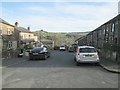
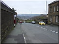
4
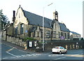
United Reformed Church, Holywell Green
This was built as the Sunday School; the church was next to it on the right, but has been demolished and the site used for houses.
Image: © Humphrey Bolton
Taken: 27 Sep 2013
0.04 miles