IMAGES TAKEN NEAR TO
Woodside Grove, HALIFAX, HX4 8BW
Introduction
This page details the photographs taken nearby to Woodside Grove, HX4 8BW by members of the Geograph project.
The Geograph project started in 2005 with the aim of publishing, organising and preserving representative images for every square kilometre of Great Britain, Ireland and the Isle of Man.

There are currently over 7.5m images from over14,400 individuals and you can help contribute to the project by visiting https://www.geograph.org.uk
Image Map (Loading...)


Getting Data...Please wait
Leaflet Map data © OpenStreetMap
Images are licensed for reuse under creativecommons.org/licenses/by-sa/2.0
Notes
- Clicking on the map will re-center to the selected point.
- The higher the marker number, the further away the image location is from the centre of the postcode.
Image Listing (149 Images Found)
Images are licensed for reuse under creativecommons.org/licenses/by-sa/2.0
Image
Details
Distance
2
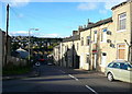
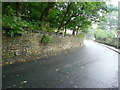
Queen Street, West Vale
This 19C residential street, connecting Stainland Road with Green Lane, is an unexpected part of the route of Stage 2 of the Tour de France, 2014.
Image: © Humphrey Bolton
Taken: 7 Nov 2013
0.04 miles
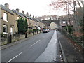
4
Workhouse Lane and Featherbed Close, Greetland
Workhouse Lane was a narrow road next to the gable on the left. The new road and houses are Featherbed Close.
Image: © Humphrey Bolton
Taken: 8 Sep 2011
0.04 miles
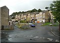
5
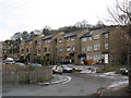
Featherbed Close, West Vale
A development of housing off Green Lane. A search of Calderdale planning applications archive reveals that the planning permission was granted in 1989 so presumably built c.1990.
Image: © Stephen Craven
Taken: 4 Jan 2011
0.04 miles
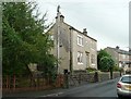
6
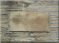
Datestone, Spring Lodge, Green Lane, Greetland
The date 1854 shows that this was one of the first houses to be built on Green Lane, then called The Old Lane, as otherwise only Woodhouse and a group of houses at Little Bradley are shown on the 1850 six-inch map.
Image: © Humphrey Bolton
Taken: 8 Sep 2011
0.05 miles
7
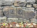
Old Boundary Marker on Hullenedge Lane, Little Bradley
Parish Boundary Marker incised in a stone set in a drystone wall on the south side of Hullenedge Lane, Little Bradley. On the former boundary of Elland and Greetland parishes, until 1894 the joint parish of Elland with Greetland. See also https://www.geograph.org.uk/photo/3744170.
Milestone Society National ID: YW_ELLGRE02pb
Image: © D Garside
Taken: 11 Nov 2022
0.05 miles
8
Boundary Stone, Hullen Edge Lane
E for Elland and G for Greetland, made after Greetland became a separate local authority, perhaps when the Urban Districts were created in 1893.
Image: © Humphrey Bolton
Taken: 3 Oct 2013
0.05 miles
9
Location of boundary stone, Hullen Edge Lane
For a close view of the stone, see Image This image also shows part of the 2014 Tour-de-France route.
Image: © Humphrey Bolton
Taken: 3 Oct 2013
0.05 miles
10
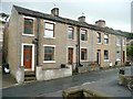
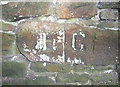
Four houses, Green Lane, Greetland
These are clearly two pairs of houses, with a difference in the courses of stone at the join. The left pair almost certainly later than the other pair, which has a datestone inscribed 'J.M.M. / Spring Lodge' / 1854' (see Image). This seems an odd name for a pair of houses. The house on the right is quite small, as it is squeezed into the angle between Green Lane and Workhouse Lane. These were called 'The Old Lane' and 'Nab End Lane' on the 1850 six-inch map. I have since been informed that the reason the houses were called Spring Lodge is because there was a well at the back of the property. This was a shared yard were the washing / laundry was done and also housed the external WCs. This shared yard is now incorporated into the house and is fittingly a downstairs bathroom and utility room. The JMM may relate to the initials of the owner of the property which research has suggested might be the name Mallinson.
Image: © Humphrey Bolton
Taken: 8 Sep 2011
0.05 miles