IMAGES TAKEN NEAR TO
Stainland Road, HALIFAX, HX4 8BD
Introduction
This page details the photographs taken nearby to Stainland Road, HX4 8BD by members of the Geograph project.
The Geograph project started in 2005 with the aim of publishing, organising and preserving representative images for every square kilometre of Great Britain, Ireland and the Isle of Man.

There are currently over 7.5m images from over14,400 individuals and you can help contribute to the project by visiting https://www.geograph.org.uk
Image Map
Images are licensed for reuse under creativecommons.org/licenses/by-sa/2.0
Notes
- Clicking on the map will re-center to the selected point.
- The higher the marker number, the further away the image location is from the centre of the postcode.
Image Listing (197 Images Found)
Images are licensed for reuse under creativecommons.org/licenses/by-sa/2.0
Image
Details
Distance
1
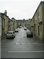
Dean Street - Stainland Road, West Vale
Image: © Betty Longbottom
Taken: 17 May 2008
0.01 miles
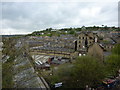
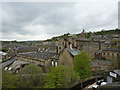
2
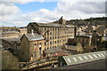
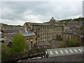
West Vale Mills
Still in use. The photo shows the main pedimented block, fine stair tower, weaving shed and two engine houses in the bottom left corner.
Image: © Chris Allen
Taken: 4 Apr 2009
0.02 miles
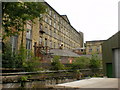
3
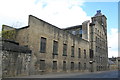
West Vale Mill
An impressive West Yorkshire textile mill complex. There is the base of a felled chimney on the left.
Image: © Chris Allen
Taken: 4 Apr 2009
0.02 miles
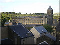
7
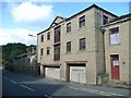
Former warehouse,Saddleworth Road B6114, Greetland
Dated 1836.
Image: © Humphrey Bolton
Taken: 2 Oct 2008
0.03 miles
10
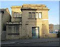
Electricity Substation No 60 - Saddleworth Road
Image: © Betty Longbottom
Taken: 30 Nov 2013
0.03 miles