IMAGES TAKEN NEAR TO
Fiddle Lane, HALIFAX, HX4 0FJ
Introduction
This page details the photographs taken nearby to Fiddle Lane, HX4 0FJ by members of the Geograph project.
The Geograph project started in 2005 with the aim of publishing, organising and preserving representative images for every square kilometre of Great Britain, Ireland and the Isle of Man.

There are currently over 7.5m images from over14,400 individuals and you can help contribute to the project by visiting https://www.geograph.org.uk
Image Map (Loading...)


Getting Data...Please wait
Leaflet Map data © OpenStreetMap
Images are licensed for reuse under creativecommons.org/licenses/by-sa/2.0
Notes
- Clicking on the map will re-center to the selected point.
- The higher the marker number, the further away the image location is from the centre of the postcode.
Image Listing (11 Images Found)
Images are licensed for reuse under creativecommons.org/licenses/by-sa/2.0
Image
Details
Distance
1
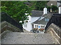
The Old Bridge Inn, Ripponden
On Priest Lane, the old Ripponden to Elland road which runs past the church. A new road was built parallel to this many years ago.
Image: © Malcolm Street
Taken: 11 Sep 2005
0.20 miles
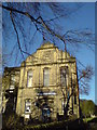
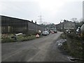
3
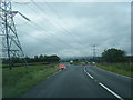
B6114 junction with Rishworth Road, and pylons
Image: © Colin Pyle
Taken: 2 Aug 2017
0.22 miles
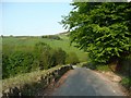
5
Gosling Lane, Barkisland
Beyond the driveway to a farm on the left, the lane has a tarmac surface to its junction with Saddleworth Road (B6114).
Image: © Humphrey Bolton
Taken: 12 May 2008
0.23 miles
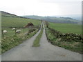
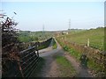
6
Rishworth Road - viewed from Fiddle Lane
Image: © Betty Longbottom
Taken: 18 Mar 2015
0.24 miles
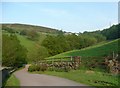
7
Bank Hey Bottom Lane, Barkisland
Looking down towards a hairpin bend next to Cob Clough.
Image: © Humphrey Bolton
Taken: 12 May 2008
0.24 miles
8
Cob Clough, Bank Hey Bottom Lane, Barkisland
Cob Clough is the valley sloping up to the right. As usual around here, there is a strip of woodland in the valley bottom.
Image: © Humphrey Bolton
Taken: 12 May 2008
0.24 miles
9
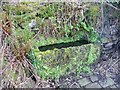
Trough, Bank Hey Bottom Lane, Barkisland
This is only a few metres up the lane from a well. Stone setts were provided to avoid a muddy patch in what would have been an unsurfaced lane before the mid-20C.
Image: © Humphrey Bolton
Taken: 12 May 2008
0.24 miles
10
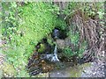
Well, Bank Hey Bottom Lane, Barkisland
This was probably the water supply for nearby cottages.
Image: © Humphrey Bolton
Taken: 12 May 2008
0.24 miles