IMAGES TAKEN NEAR TO
Blaithroyd Court, HALIFAX, HX3 9PT
Introduction
This page details the photographs taken nearby to Blaithroyd Court, HX3 9PT by members of the Geograph project.
The Geograph project started in 2005 with the aim of publishing, organising and preserving representative images for every square kilometre of Great Britain, Ireland and the Isle of Man.

There are currently over 7.5m images from over14,400 individuals and you can help contribute to the project by visiting https://www.geograph.org.uk
Image Map
Images are licensed for reuse under creativecommons.org/licenses/by-sa/2.0
Notes
- Clicking on the map will re-center to the selected point.
- The higher the marker number, the further away the image location is from the centre of the postcode.
Image Listing (71 Images Found)
Images are licensed for reuse under creativecommons.org/licenses/by-sa/2.0
Image
Details
Distance


3
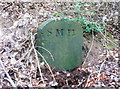
Boundary stone for the former St Michael and All Angels' Mission Church, Halifax
This church was on Southowram Bank. It was opened on 30 April 1887 and demolished in 1967 (information from Malcom Bull's Calderdale Companion).
There is now a house on the site, but the retaining wall and iron railings alongside the road are still there. An old 1:2500 map shows a number of 'stones' in an arc in the woodland below the church. This one and another near the road can be seen from the public footpath. They both have the letters 'SMH', presumably for St Michael's Halifax.
Image: © Humphrey Bolton
Taken: 29 Mar 2018
0.06 miles
4
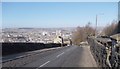
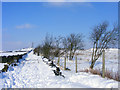
Southowram Bank - looking down from off Beacon Hill Road
Image: © Betty Longbottom
Taken: 2 Mar 2013
0.07 miles
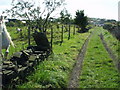
5
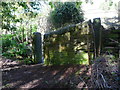
Stile on Halifax FP594 at Southowram Bank
This narrow stile is at one end of a walled-up gateway.
Image: © Humphrey Bolton
Taken: 25 Apr 2017
0.07 miles
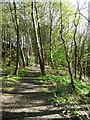
6
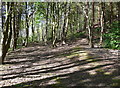
Halifax FPs 593 and 594
Both these paths lead to Southowram Bank. 593 on the left is the wider one here, but where it reaches the road there is no stile and you have to climb over the wall. 594 goes to a narrow stile at one end of a walled-up gateway.
Image: © Humphrey Bolton
Taken: 25 Apr 2017
0.07 miles
7
A white Green Lane
Looking towards the summit of Beacon Hill. The mound on the right screens Beacon Lodge Quarry
Image: © Phil Champion
Taken: 3 Feb 2009
0.07 miles
9
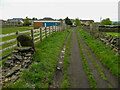
Green Lane, Southowram
The grid reference and the leaning slab of stone show that this is the same view as in Image] taken in 2004. Trees have been removed, and there is a large new building, possibly stables.
Image: © Humphrey Bolton
Taken: 13 May 2021
0.08 miles
10
Green Lane, Bank Top, Southowram
View south along Green Lane (footpath Halifax 589) towards Bank Top.
The area to the left of the picture has been extensively quarried and backfilled during the twentieth century. Evidence of this activity can clearly been seen in the humps and hollows on the field. Limited sandstone extraction still takes place at Beacon Lodge Quarry, just out of shot. Halifax town centre is less than a mile away down the steep hillside to the west.
Image: © Phil Champion
Taken: 10 Sep 2004
0.08 miles