IMAGES TAKEN NEAR TO
School Cote Brow, HALIFAX, HX3 6SR
Introduction
This page details the photographs taken nearby to School Cote Brow, HX3 6SR by members of the Geograph project.
The Geograph project started in 2005 with the aim of publishing, organising and preserving representative images for every square kilometre of Great Britain, Ireland and the Isle of Man.

There are currently over 7.5m images from over14,400 individuals and you can help contribute to the project by visiting https://www.geograph.org.uk
Image Map
Images are licensed for reuse under creativecommons.org/licenses/by-sa/2.0
Notes
- Clicking on the map will re-center to the selected point.
- The higher the marker number, the further away the image location is from the centre of the postcode.
Image Listing (46 Images Found)
Images are licensed for reuse under creativecommons.org/licenses/by-sa/2.0
Image
Details
Distance
2
Queensbury FP31 at Brow Lane
The path goes up the driveway, the one on the left, to Ambler Thorp Fireclay Works.
Image: © Humphrey Bolton
Taken: 30 Nov 2017
0.03 miles
3
Queensbury FP31 on the driveway to Ambler Thorp Fireclay Works
Image: © Humphrey Bolton
Taken: 30 Nov 2017
0.03 miles
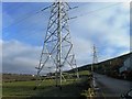
5
Hillside above Holmfield
From Crooked Lane just above Brigg Royd, with a pylon above Holmfield Mills.
Image: © Derek Harper
Taken: 3 Jul 2014
0.07 miles
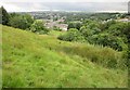
6
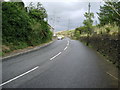
Crooked Lane
From its junction with Windy Bank Lane, and used by the Calderdale Way. This is also Halifax byway open to all traffic 745, and forms the Metropolitan District boundary.
Image: © Derek Harper
Taken: 3 Jul 2014
0.09 miles
7
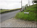
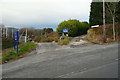
Windy Bank Lane
The junction with Crooked Lane, taken from the same spot as Image
Image: © Derek Harper
Taken: 3 Jul 2014
0.10 miles
8
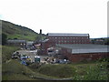
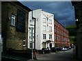
Netterton Mills
The chimney is for White Rose Mill
Image: © Alexander P Kapp
Taken: 8 Sep 2009
0.10 miles
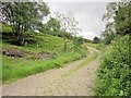
9
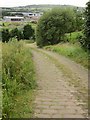
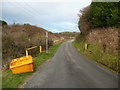
Crooked Lane
Relatively straight, in fact. The steep cobbled byway (Halifax BOAT 745) carries the Calderdale Way and is an administrative boundary. In the background is Holmfield Industrial Estate.
Image: © Derek Harper
Taken: 3 Jul 2014
0.11 miles