IMAGES TAKEN NEAR TO
Rishworthian Court, HALIFAX, HX3 0UL
Introduction
This page details the photographs taken nearby to Rishworthian Court, HX3 0UL by members of the Geograph project.
The Geograph project started in 2005 with the aim of publishing, organising and preserving representative images for every square kilometre of Great Britain, Ireland and the Isle of Man.

There are currently over 7.5m images from over14,400 individuals and you can help contribute to the project by visiting https://www.geograph.org.uk
Image Map
Images are licensed for reuse under creativecommons.org/licenses/by-sa/2.0
Notes
- Clicking on the map will re-center to the selected point.
- The higher the marker number, the further away the image location is from the centre of the postcode.
Image Listing (102 Images Found)
Images are licensed for reuse under creativecommons.org/licenses/by-sa/2.0
Image
Details
Distance
3
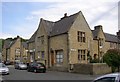
Shop, Copley, Skircoat (Halifax)
Several shops were provided in Copley village, but only one survives. The others were converted to houses, but can still be identified by the large window.
Image: © Humphrey Bolton
Taken: 4 Jun 2006
0.05 miles
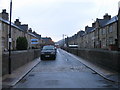
4
Terrace houses, Copley, Skircoat (Halifax)
These were built from 1849 onwards. They are back-to back houses with the door leading straight into the living room, and a scullery with a small window at the side. Upstairs are two bedrooms and there are cellars beneath. I suspect that most have been converted to through houses to give space for bathrooms and kitchens to modern standards.
Image: © Humphrey Bolton
Taken: 4 Jun 2006
0.05 miles
5
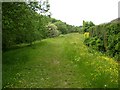
Footpath alongside the River Calder, Copley, Skircoat (Halifax)
This grassy path is on a broad flood bank.
Image: © Humphrey Bolton
Taken: 4 Jun 2006
0.06 miles
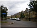
7
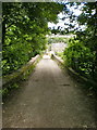
Road
From St Stephen's Church to Copley Lane over the River Calder (Copley Bridge)
Image: © Alexander P Kapp
Taken: 14 Jul 2009
0.07 miles
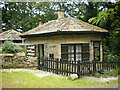
9
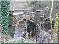
Copley Bridge, collapsed, upstream side
The northern arch is severely damaged and the southern arch has gone. The bridge is privately owned, so is unlikely to be rebuilt. There is a public footpath across it and the council intend to build a footbridge, which will presumably also carry the services.
Image: © Humphrey Bolton
Taken: 18 Jan 2016
0.08 miles
10
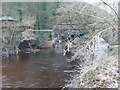
Copley Bridge, collapsed, downstream side
The southern arch has gone, leaving the services suspended in mid-air. Access to the church and the former toll cottage is now via an unsurfaced road from Upper Greetland.
Image: © Humphrey Bolton
Taken: 18 Jan 2016
0.08 miles