IMAGES TAKEN NEAR TO
St. Stephens Street, HALIFAX, HX3 0UH
Introduction
This page details the photographs taken nearby to St. Stephens Street, HX3 0UH by members of the Geograph project.
The Geograph project started in 2005 with the aim of publishing, organising and preserving representative images for every square kilometre of Great Britain, Ireland and the Isle of Man.

There are currently over 7.5m images from over14,400 individuals and you can help contribute to the project by visiting https://www.geograph.org.uk
Image Map
Images are licensed for reuse under creativecommons.org/licenses/by-sa/2.0
Notes
- Clicking on the map will re-center to the selected point.
- The higher the marker number, the further away the image location is from the centre of the postcode.
Image Listing (99 Images Found)
Images are licensed for reuse under creativecommons.org/licenses/by-sa/2.0
Image
Details
Distance
1
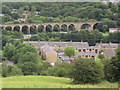
West end of Copley village
A view from North Dean Woods across the village showing old and new housing, with the viaduct behind. See also Image taken some years earlier which gives some historical notes.
Image: © Stephen Craven
Taken: 6 Jul 2014
0.03 miles
2
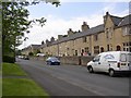
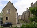
Terrace houses, Copley, Skircoat (Halifax)
These were built from 1849 onwards. They are back-to back houses with the door leading straight into the living room, and a scullery with a small window at the side. Upstairs are two bedrooms and there are cellars beneath. I suspect that most have been converted to through houses to give space for bathrooms and kitchens to modern standards.
Image: © Humphrey Bolton
Taken: 4 Jun 2006
0.05 miles
3
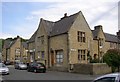
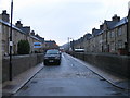
Shop, Copley, Skircoat (Halifax)
Several shops were provided in Copley village, but only one survives. The others were converted to houses, but can still be identified by the large window.
Image: © Humphrey Bolton
Taken: 4 Jun 2006
0.05 miles
4
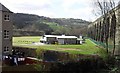
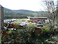
Copley Cricket Club and Copley Viaduct
Copley Cricket Club bounded on the right by Copley Viaduct, at the back by the railway line between Sowerby Bridge and Brighouse and in the foreground by a housing estate built in 2006. The photo was taken from the towpath of the Leeds/Rochdale canal and Norland Town is on the hillside above the clubhouse.
Image: © charlieboyce
Taken: 20 Apr 2010
0.06 miles
6
Through terrace houses, Copley, Skircoat (Halifax)
These were built in 1865 in response to objections to back-to-back houses. However there was little improvement as only one small window was provided in the rear wall of each house.
Image: © Humphrey Bolton
Taken: 4 Jun 2006
0.08 miles
7
New cricket pavilion almost completed, Copley
Image: © Humphrey Bolton
Taken: 1 Apr 2012
0.08 miles

10

View over Copley from 084221
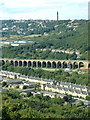
Standing on the Calderdale Way and looking northwards, the line of the L&Y railway can be traced from middle left, where is Milner Royd Junction, across the picture to bottom right, on the way to Elland. The fine viaduct is on the Halifax branch, which curves sharply on a rising gradient. This line still has passenger trains, but the old L&Y main line does not. Prominent on the skyline is the Wainhouse Tower, actually constructed as a mill chimney but never used as such.
Image: © Dr Neil Clifton
Taken: 17 Aug 1987
0.09 miles