IMAGES TAKEN NEAR TO
Whitehill Road, HALIFAX, HX2 9UD
Introduction
This page details the photographs taken nearby to Whitehill Road, HX2 9UD by members of the Geograph project.
The Geograph project started in 2005 with the aim of publishing, organising and preserving representative images for every square kilometre of Great Britain, Ireland and the Isle of Man.

There are currently over 7.5m images from over14,400 individuals and you can help contribute to the project by visiting https://www.geograph.org.uk
Image Map
Images are licensed for reuse under creativecommons.org/licenses/by-sa/2.0
Notes
- Clicking on the map will re-center to the selected point.
- The higher the marker number, the further away the image location is from the centre of the postcode.
Image Listing (50 Images Found)
Images are licensed for reuse under creativecommons.org/licenses/by-sa/2.0
Image
Details
Distance
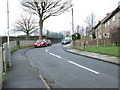
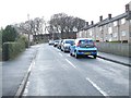
1

Cedar Grange Retirement Home - Whitehill Road
Image: © Betty Longbottom
Taken: 24 Feb 2014
0.03 miles
4
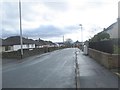
Alloe Field Place - viewed from Moss Drive
Image: © Betty Longbottom
Taken: 24 Feb 2014
0.06 miles
7
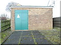
Electricity Substation No 1495 - Moor Bottom Road
Image: © Betty Longbottom
Taken: 24 Feb 2014
0.08 miles
8
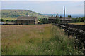
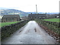
Threapland
Small farm located off Whitehill Road in the Illingworth suburb of Halifax
Image: © Chris Heaton
Taken: 14 Jun 2020
0.09 miles
9
Alloe Field View - from Moss Drive
Image: © Betty Longbottom
Taken: 24 Feb 2014
0.09 miles
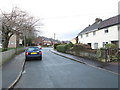
10
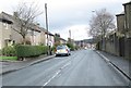
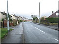
Moor Bottom Road - viewed from Whitehill Road
Image: © Betty Longbottom
Taken: 24 Feb 2014
0.09 miles