IMAGES TAKEN NEAR TO
Park Lane Ends, HALIFAX, HX2 8XE
Introduction
This page details the photographs taken nearby to Park Lane Ends, HX2 8XE by members of the Geograph project.
The Geograph project started in 2005 with the aim of publishing, organising and preserving representative images for every square kilometre of Great Britain, Ireland and the Isle of Man.

There are currently over 7.5m images from over14,400 individuals and you can help contribute to the project by visiting https://www.geograph.org.uk
Image Map
Images are licensed for reuse under creativecommons.org/licenses/by-sa/2.0
Notes
- Clicking on the map will re-center to the selected point.
- The higher the marker number, the further away the image location is from the centre of the postcode.
Image Listing (51 Images Found)
Images are licensed for reuse under creativecommons.org/licenses/by-sa/2.0
Image
Details
Distance
1
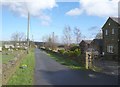
Blind Lane, Illingworth
A bridleway, closed to motor vehicles after South Peat Pitts, which is the house in the distance.
Image: © Humphrey Bolton
Taken: 26 Mar 2009
0.05 miles
2
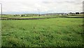
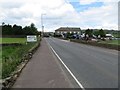
Field by the A629
From the Calderdale Way following Per Lane. The A road soon crosses into Image Ahead are the outskirts of Illingworth.
Image: © Derek Harper
Taken: 3 Jul 2014
0.05 miles
3
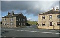
Cow Hill Gate Lane, Illingworth
At its junction with Keighley Road, with a house on each side.
Image: © Humphrey Bolton
Taken: 26 Mar 2009
0.08 miles
4

Mount Zion Methodist Church, Upper Brockholes, Graveyard
Image: © Alexander P Kapp
Taken: 1 Dec 2008
0.09 miles
5
Per Lane, Upper Brockholes
A little further along Image] and the Calderdale Way, approaching the crossing of the A629. On the left is Soil Hill.
Image: © Derek Harper
Taken: 3 Jul 2014
0.09 miles
6
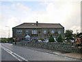
Peat Pits Inn (The Moorlands), Ovenden
A pub-restaurant with accommodation, welcoming walkers - it is near to Ogden Reservoir and access land on the moors.
Image: © Humphrey Bolton
Taken: 26 Mar 2009
0.10 miles
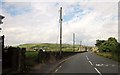
7
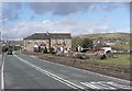
Keighley Road (A629) at The Moorlands Inn
Looking northward.
Image: © Peter Wood
Taken: 19 Jun 2019
0.10 miles
9

Mount Zion Methodist Church, Upper Brockholes, Sundial
Image: © Alexander P Kapp
Taken: 1 Dec 2008
0.11 miles
10
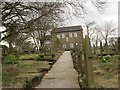
Upper Brockholes Sion Chapel
Mount Sion Methodist Church. Grade II.
Original building 1773, chapel rebuilt 1815, interior refitted c1870.
Central vesica shaped plaque inscribed: This Chapel / was rebuilt in / the year / 1815
Above is a reset sundial inscribed: A.D. 1773. / Mount Sion
Image: © Andrew Riley
Taken: 22 Apr 2008
0.11 miles