IMAGES TAKEN NEAR TO
Wainstalls, HALIFAX, HX2 7TR
Introduction
This page details the photographs taken nearby to HX2 7TR by members of the Geograph project.
The Geograph project started in 2005 with the aim of publishing, organising and preserving representative images for every square kilometre of Great Britain, Ireland and the Isle of Man.

There are currently over 7.5m images from over14,400 individuals and you can help contribute to the project by visiting https://www.geograph.org.uk
Image Map
Images are licensed for reuse under creativecommons.org/licenses/by-sa/2.0
Notes
- Clicking on the map will re-center to the selected point.
- The higher the marker number, the further away the image location is from the centre of the postcode.
Image Listing (35 Images Found)
Images are licensed for reuse under creativecommons.org/licenses/by-sa/2.0
Image
Details
Distance
1
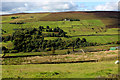
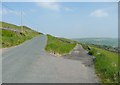
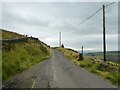
Across Luddenden Dean from Castle Carr Road
Image: © Chris Heaton
Taken: 15 Sep 2017
0.04 miles
2
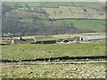
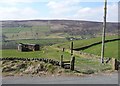
Lower Heys, Warley
A farm built on the hillside, its position perhaps chosen to be at a spring. The view is down into the valley of Luddenden Brook.
Image: © Humphrey Bolton
Taken: 2 Apr 2009
0.05 miles
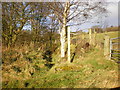
3
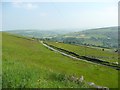
View of Halifax Bridleway 155
This lane is older than Castle Carr Road, which did not exist when the 1850 six-inch map was made.
Image: © Humphrey Bolton
Taken: 10 Jun 2013
0.05 miles
4
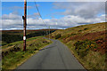
Castle Carr Road (1)
High level lane that runs below the southern end of Warley Moor, towards the Dean Head Reservoirs.
Access is barred however on arrival at the castellated building and archway of Castle Carr Lodges. Signs make it quite clear the route beyond is private and out of bounds to the public. An individual leaning on the barrier looked quite eager for a confrontation on the matter.
The alternative to further progress is open access moorland over Height Edge and Too To Hill, an awkward trudge over difficult terrain.
Image: © Chris Heaton
Taken: 15 Sep 2017
0.07 miles
5
The western end of Halifax Bridleway 155
This bridleway is along a farm access track, and forms a loop to the south of Castle Carr Road.
Image: © Humphrey Bolton
Taken: 10 Jun 2013
0.10 miles
6
Footpath off the N side of Saltonstall Lane
E of Upper Saltonstall
Image: © Alexander P Kapp
Taken: 1 Dec 2008
0.13 miles
7
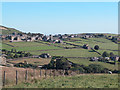
Wainstalls, Moorland Village
View South East showing some of the properties which were formerly small woollen mills now converted to houses.
Image: © Dennis Turner
Taken: 14 Sep 2003
0.14 miles
8
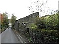
Traditional Farm Building opposite Throstle Bower
Image: © Michael Steele
Taken: 17 Oct 2009
0.15 miles
9
Castle Carr Road
Heading towards Wainstalls having just crossed Heys Clough
Image: © Kevin Waterhouse
Taken: 12 Aug 2024
0.16 miles
10
Footpath opposite Heys Clough, Castle Carr Road, Warley
A cart track at first, but from the map it becomes a field path as it descends to Upper Heys Wood. The clough has become just a depression on the right-hand side of the wall. There are two old railway vans in the field.
Image: © Humphrey Bolton
Taken: 2 Apr 2009
0.16 miles