IMAGES TAKEN NEAR TO
Rose Mount, Delph Hill, HALIFAX, HX2 7EQ
Introduction
This page details the photographs taken nearby to Rose Mount, Delph Hill, HX2 7EQ by members of the Geograph project.
The Geograph project started in 2005 with the aim of publishing, organising and preserving representative images for every square kilometre of Great Britain, Ireland and the Isle of Man.

There are currently over 7.5m images from over14,400 individuals and you can help contribute to the project by visiting https://www.geograph.org.uk
Image Map
Images are licensed for reuse under creativecommons.org/licenses/by-sa/2.0
Notes
- Clicking on the map will re-center to the selected point.
- The higher the marker number, the further away the image location is from the centre of the postcode.
Image Listing (138 Images Found)
Images are licensed for reuse under creativecommons.org/licenses/by-sa/2.0
Image
Details
Distance
1
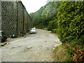
Halifax FP671 leaving Rose Terrace, Skircoat
The path goes through woodland to Wakefield Gate. The woodland is part of the area of the former Delf Hill quarry.
Image: © Humphrey Bolton
Taken: 2 Aug 2018
0.01 miles
2
Halifax FP671 on Rose Terrace, Skircoat
Rose Terrace is three blocks of terrace houses built on the edge of the Delf Hill quarry c.1900.
Image: © Humphrey Bolton
Taken: 2 Aug 2018
0.03 miles
3
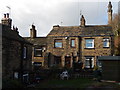
Pre 1850 Housing in Delph Hill Road (part of Delph Hill Terrace)
The stone roof demonstrates that these houses were built before the railways made cheaper roofs, constructed from Welsh slate, available in the West Riding of Yorkshire.
Image: © Michael Steele
Taken: 2 Feb 2014
0.03 miles
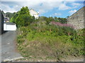
5
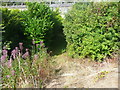
Halifax FP671 approaching Rose Terrace, Skircoat
The path goes between the bushes.
Image: © Humphrey Bolton
Taken: 2 Aug 2018
0.05 miles
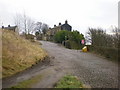
6
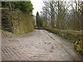
Delph Hill Road from junction with Spring Terrace
'Delph' means quarry. The land over which the road was constructed was owned by John Edward Wainhouse, whose famous tower can be seen in the centre background. The wall on the right is a 'Judd' wall constructed of quarry waste, and there is evidence of quarrying having occurred to the left.
Image: © Michael Steele
Taken: 2 Feb 2014
0.05 miles
7
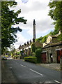
Scarr Bottom Road
With Wainhouse Tower in the distance
Image: © Alexander P Kapp
Taken: 14 Jul 2009
0.05 miles
8
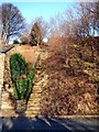
Flight of 100 steps between Scarr Bottom Road and Delph Hill
Image: © Michael Steele
Taken: 2 Feb 2014
0.06 miles
9
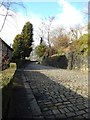
Wakefield Gate
Still paved with setts.
Image: © Alexander P Kapp
Taken: 16 Dec 2008
0.06 miles
10
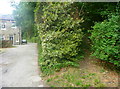
Halifax FP671 off Delph Hill Road, Skircoat
The path is not obvious, but seems to be on the bank to the right of the driveway.
Image: © Humphrey Bolton
Taken: 2 Aug 2018
0.06 miles