IMAGES TAKEN NEAR TO
Brearley, Luddendenfoot, HALIFAX, HX2 6JD
Introduction
This page details the photographs taken nearby to HX2 6JD by members of the Geograph project.
The Geograph project started in 2005 with the aim of publishing, organising and preserving representative images for every square kilometre of Great Britain, Ireland and the Isle of Man.

There are currently over 7.5m images from over14,400 individuals and you can help contribute to the project by visiting https://www.geograph.org.uk
Image Map
Images are licensed for reuse under creativecommons.org/licenses/by-sa/2.0
Notes
- Clicking on the map will re-center to the selected point.
- The higher the marker number, the further away the image location is from the centre of the postcode.
Image Listing (135 Images Found)
Images are licensed for reuse under creativecommons.org/licenses/by-sa/2.0
Image
Details
Distance
1
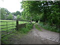
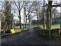
Road to Great Scout Farm
With Green Field to been seen in amongst the trees
Image: © Alexander P Kapp
Taken: 28 May 2009
0.02 miles
2
Hebden Royd FP57 (3) - Approaching Green Field, Mytholmroyd
This is the western branch of this footpath, on the driveway to Great Scout.
Image: © Humphrey Bolton
Taken: 3 Oct 2016
0.03 miles
3
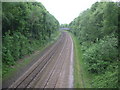
Todmorden to Halifax Railway
Looking west from Brearley Lane
Image: © Alexander P Kapp
Taken: 28 May 2009
0.04 miles
4
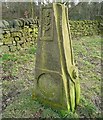
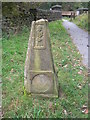
Murder Stone, Mytholmroyd
Possibly one of the sculpted stones commissioned by Sustrans to add interest to the National Cycle Route Network. "A full and true Account / Of a barbrous bloody and inhuman MURDER" and below a depiction of the die for a fake coin, dated 1722.
Image: © Humphrey Bolton
Taken: 27 Feb 2009
0.06 miles
5
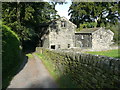
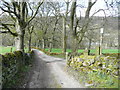
Blind Lane
This view is of the foot of the lane, at the top of Brearley Lane.
Image: © Humphrey Bolton
Taken: 11 Dec 2012
0.07 miles
6
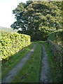
Hebden Royd FP57 (2) - On the driveway to Great Scout, Mytholmroyd
This is the western branch of this footpath.
Image: © Humphrey Bolton
Taken: 3 Oct 2016
0.07 miles
7
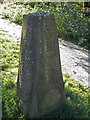
"Bloody and inhuman murder"
This stone at the side of the Sustrans Route 66 near Mytholmroyd commemorates a bloody episode in the Cragg Coiners story. It reminds us that in November 1769 the gang of counterfeiters shot Williiam Deighton, the investigating Excise officer, who was hot on their heels. The murderers were caught and executed. The carved inscription on the stone (beneath the depiction of a skeleton) is difficult to read but I think it says, "A true and full account of a barbarous, bloody and inhuman murder".
Image: © michael ely
Taken: 28 Sep 2008
0.07 miles
8
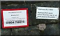
Signs on the railway bridge, Brearley Lane
This bridge was constructed to carry the diverted route of Blind Lane, which gave and still does give access to several properties. It is also a public footpath. It does therefore seem strange that Railtrack have stated that the way is not dedicated to the public.
Image: © Humphrey Bolton
Taken: 11 Dec 2012
0.08 miles
9
Murder Stone and Railway Bridge, Mytholmroyd
Image: © John Topping
Taken: 25 Sep 2009
0.08 miles
10
Hob Lane, Mytholmroyd
Here the lane is approaching the junction with Blind Lane. There is an old street lamp at the junction.
Image: © Humphrey Bolton
Taken: 17 Apr 2016
0.08 miles