IMAGES TAKEN NEAR TO
Cooperfields, HALIFAX, HX2 6AT
Introduction
This page details the photographs taken nearby to Cooperfields, HX2 6AT by members of the Geograph project.
The Geograph project started in 2005 with the aim of publishing, organising and preserving representative images for every square kilometre of Great Britain, Ireland and the Isle of Man.

There are currently over 7.5m images from over14,400 individuals and you can help contribute to the project by visiting https://www.geograph.org.uk
Image Map
Images are licensed for reuse under creativecommons.org/licenses/by-sa/2.0
Notes
- Clicking on the map will re-center to the selected point.
- The higher the marker number, the further away the image location is from the centre of the postcode.
Image Listing (89 Images Found)
Images are licensed for reuse under creativecommons.org/licenses/by-sa/2.0
Image
Details
Distance
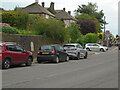
1
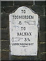
Milestone
Set in the wall opposite the former church on Burnley Road
Image: © Alexander P Kapp
Taken: 15 Oct 2008
0.01 miles
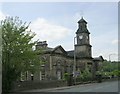
2
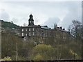
Former Congregational Church on Burnley Road, Luddenden Foot
Rear view
Image: © Alexander P Kapp
Taken: 7 Apr 2010
0.03 miles
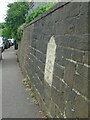
3
Old Milestone by the A646, Burnley Road, Luddenden Foot
Carved stone post by the A646, in parish of Halifax (Calderdale District), Luddenden Foot, Burnley Road, opposite clock tower building, in wall, 3 courses up, on East side of road. Todmorden rolltop, erected by the Todmorden turnpike trust in the 18th/19th century.
Inscription reads:-
TO
TODMORDEN
8 {<-hand}
TO
HALIFAX
{hand->} 3¾
{fancy line}
LUDDENDENFOOT
{fancy line}
Carved benchmark on wall below MS.
Grade II listed.
List Entry Number: 1134554 https://historicengland.org.uk/listing/the-list/list-entry/1134554
Milestone Society National ID: YW_TOHA08
Image: © C Minto
Taken: 1 Dec 2002
0.03 miles
4
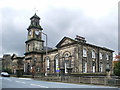
Former church on Burnley Road
Has been converted into housing
Image: © Alexander P Kapp
Taken: 15 Oct 2008
0.04 miles
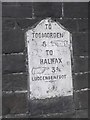
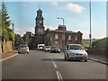
5
Old milestone
Travelling towards Halifax along the A646 this shows the position of the milestone in relation to street, Cooper Fields, the road signs and the bus-stop.
Grade II listed 1134554.
Image: © Chris Minto
Taken: 25 May 2024
0.04 miles
6
Old milestone
This shows how high the milestone on the A646 in Luddendenfoot is set in the wall. There are several others of this design on this road towards Todmorden, also on Rochdale Road A6033 southwards and Burnley Road A646 northwest out of Todmorden. They may have been set up by the Todmorden Trust which was set up in 1771 and covered 16.8 miles or the Halifax, Sowerby Bridge, Todmorden Trust of 1760. There is faint cut benchmark on the stone below the milestone.
Grade II listed 1134554.
Image: © Chris Minto
Taken: 25 May 2024
0.04 miles
7
Former Chapel - Burnley Road, Luddenden Foot
Image: © Betty Longbottom
Taken: 20 May 2008
0.05 miles
8
Former Congregational Church on Burnley Road, Luddenden Foot
Image: © David Dixon
Taken: 3 Sep 2010
0.05 miles
9
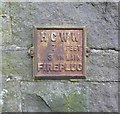
Old fire hydrant plate, Burnley Road
'Fireplug' is an old word for 'fire hydrant', still used in the USA. HCWW presumably stands for Halifax Corporation Water Works.
Image: © Humphrey Bolton
Taken: 12 Feb 2013
0.05 miles
10
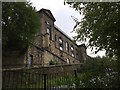
Rear of former Congregational church, Burnley Road
Overlooking the Calder valley. Now converted into housing.
Image: © John H Darch
Taken: 7 Oct 2017
0.05 miles