IMAGES TAKEN NEAR TO
Burnley Road, HALIFAX, HX2 6AA
Introduction
This page details the photographs taken nearby to Burnley Road, HX2 6AA by members of the Geograph project.
The Geograph project started in 2005 with the aim of publishing, organising and preserving representative images for every square kilometre of Great Britain, Ireland and the Isle of Man.

There are currently over 7.5m images from over14,400 individuals and you can help contribute to the project by visiting https://www.geograph.org.uk
Image Map
Images are licensed for reuse under creativecommons.org/licenses/by-sa/2.0
Notes
- Clicking on the map will re-center to the selected point.
- The higher the marker number, the further away the image location is from the centre of the postcode.
Image Listing (132 Images Found)
Images are licensed for reuse under creativecommons.org/licenses/by-sa/2.0
Image
Details
Distance
1
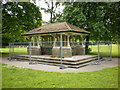
"Hope it does not rain"
Shelter under repair, Luddenden Foot Park
Image: © Alexander P Kapp
Taken: 3 Jun 2009
0.02 miles
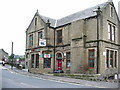
2
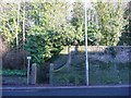
Entrance to the former Denholme Free United Methodist Chapel
Built before 1894. Demolished in the 1960s when property on Burnley Road was cleared. (from Malcolm Bull’s Calderdale Companion)
Image: © Humphrey Bolton
Taken: 11 Dec 2012
0.02 miles
3
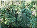
Burial ground of the former Denholme Free United Methodist Chapel, Luddendenfoot
The chapel occupied most of the site, and the gravestones seem to be confined to the corner next to the entrance steps.
Image: © Humphrey Bolton
Taken: 11 Dec 2012
0.02 miles
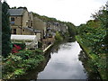
4
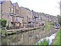
Canalside houses
A row of houses by the Rochdale Canal at Luddenden Foot
Image: © John Illingworth
Taken: 16 May 2012
0.02 miles
5
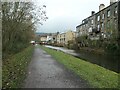
New and old canalside housing, Luddendenfoot
The walls of the older terraces have been blackened by air pollution.
Image: © Christine Johnstone
Taken: 8 Dec 2020
0.02 miles
7
Part-tiled wall belonging to the former Denholme Free United Methodist Chapel, Luddendenfoot
This was the outside of the wall of the main building, and was presumably part of the toilets.
Image: © Humphrey Bolton
Taken: 11 Dec 2012
0.03 miles
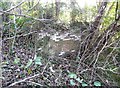
8
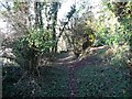
Path out of the chapel site
This path is not shown on old 1:2500 maps, so has presumably been trodden relatively recently. It probably joins the back lane behind the demolished terrace houses that were along Burnley Road, which leads to Danny Lane.
Image: © Humphrey Bolton
Taken: 11 Dec 2012
0.03 miles
9
Rochdale Canal
Looking S from Luddenden Foot Bridge
Image: © Alexander P Kapp
Taken: 15 Oct 2008
0.03 miles