IMAGES TAKEN NEAR TO
Ovenden Wood Road, HALIFAX, HX2 0TQ
Introduction
This page details the photographs taken nearby to Ovenden Wood Road, HX2 0TQ by members of the Geograph project.
The Geograph project started in 2005 with the aim of publishing, organising and preserving representative images for every square kilometre of Great Britain, Ireland and the Isle of Man.

There are currently over 7.5m images from over14,400 individuals and you can help contribute to the project by visiting https://www.geograph.org.uk
Image Map
Images are licensed for reuse under creativecommons.org/licenses/by-sa/2.0
Notes
- Clicking on the map will re-center to the selected point.
- The higher the marker number, the further away the image location is from the centre of the postcode.
Image Listing (54 Images Found)
Images are licensed for reuse under creativecommons.org/licenses/by-sa/2.0
Image
Details
Distance
2
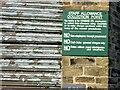
Staff Beer Collection Sign at Webster's Brewery
Perks of the job, now lost with the demolition of the brewery
Image: © Kevin Waterhouse
Taken: 15 Dec 2005
0.01 miles
3

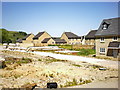
Maltings Road, Ovenden
Part of the new housing development on the site of Webster's brewery.
Image: © Humphrey Bolton
Taken: 20 Mar 2009
0.03 miles
4
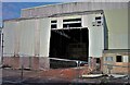
Webster's Brewery Bottling Hall
The sign reads Tanker Reception Bottling Department. Other beer brands had been bottled at this site, delivered by tanker. At this time the brewery was being demolished and replaced by housing
Image: © Kevin Waterhouse
Taken: 15 Dec 2005
0.03 miles
5
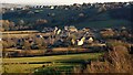
Fountainhead Village Panorama
This is a housing development on the site of the former Fountain Head Brewery of Samuel Websters. Viewed from Gibb Lane, Mount Tabor to the North West
Image: © Kevin Waterhouse
Taken: 7 Mar 2010
0.04 miles
6
Industrial buildings, former Fountain Head Brewery
Looking E. The writing says "This tank cleaned and degassed Fri 15-11-96". The brewery closed in 1996.
Image: © Mark Anderson
Taken: 18 Aug 2005
0.05 miles
7
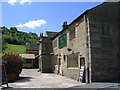
Long Can Hall - Ovenden Wood Road
The building has a date stone showing 1708.
Image: © Betty Longbottom
Taken: 28 May 2010
0.05 miles
8
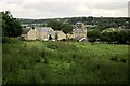
The Old Maltings, Fountain Head Brewery
The Old Maltings are on the right. "An outstanding example of its type built to a scale that evinces the success of the late C19 brewery trade in this area" http://list.english-heritage.org.uk/resultsingle.aspx?uid=1138779&searchtype=mapsearch . Built in 1906, it has been converted to offices. To the left are houses on Coopers Close. View from Ovenden Wood Road with the Hebble Brook valley in the background.
Image: © Derek Harper
Taken: 3 Jul 2014
0.05 miles
9
Draymans Court - Ovenden Wood Road
Image: © Betty Longbottom
Taken: 28 May 2010
0.06 miles
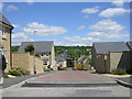
10
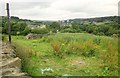
Towards Fountain Head Brewery
From Ovenden Wood Road, looking across fields and an incomplete wall to the slate roofs of the Old Maltings at Fountain Head Brewery, built in 1906 and now offices. "An outstanding example of its type built to a scale that evinces the success of the late C19 brewery trade in this area" http://list.english-heritage.org.uk/resultsingle.aspx?uid=1138779&searchtype=mapsearch . The blocks of flats behind it are at Mixenden, up the Hebble Brook valley.
Image: © Derek Harper
Taken: 3 Jul 2014
0.06 miles