IMAGES TAKEN NEAR TO
Paddock Lane, HALIFAX, HX2 0NT
Introduction
This page details the photographs taken nearby to Paddock Lane, HX2 0NT by members of the Geograph project.
The Geograph project started in 2005 with the aim of publishing, organising and preserving representative images for every square kilometre of Great Britain, Ireland and the Isle of Man.

There are currently over 7.5m images from over14,400 individuals and you can help contribute to the project by visiting https://www.geograph.org.uk
Image Map
Images are licensed for reuse under creativecommons.org/licenses/by-sa/2.0
Notes
- Clicking on the map will re-center to the selected point.
- The higher the marker number, the further away the image location is from the centre of the postcode.
Image Listing (48 Images Found)
Images are licensed for reuse under creativecommons.org/licenses/by-sa/2.0
Image
Details
Distance
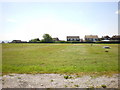
2
West End Golf Course - viewed from Paddock Lane
Image: © Betty Longbottom
Taken: 16 Jun 2014
0.03 miles
3
West End Golf Course - Paddock Lane
Image: © Betty Longbottom
Taken: 4 Aug 2008
0.04 miles
4
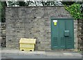
Electricity Substation No 1660 - Paddock Lane
Image: © Betty Longbottom
Taken: 16 Jun 2014
0.09 miles
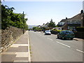
5
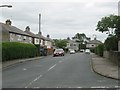
Gleanings Avenue - off Paddock Lane
Image: © Betty Longbottom
Taken: 16 Jun 2014
0.09 miles
6
Gleanings Avenue - looking towards Paddock Lane
Image: © Betty Longbottom
Taken: 16 Jun 2014
0.09 miles
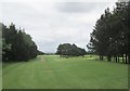
7
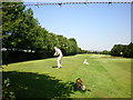
West End Golf Course
This person's drive was good, but his partner put his in the trees down the left hand side.
Image: © Alexander P Kapp
Taken: 2 Jul 2009
0.11 miles
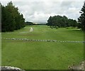
8
Bridleway heading North East towards Rushton Hill
Forms the boundary between West End Golf Course and Highroad Well Moor
Image: © Chris Heaton
Taken: 14 Jun 2020
0.12 miles
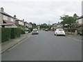
9
Gleanings Drive - Gleanings Avenue
Image: © Betty Longbottom
Taken: 16 Jun 2014
0.12 miles