IMAGES TAKEN NEAR TO
Moor Top Road, HALIFAX, HX2 0NP
Introduction
This page details the photographs taken nearby to Moor Top Road, HX2 0NP by members of the Geograph project.
The Geograph project started in 2005 with the aim of publishing, organising and preserving representative images for every square kilometre of Great Britain, Ireland and the Isle of Man.

There are currently over 7.5m images from over14,400 individuals and you can help contribute to the project by visiting https://www.geograph.org.uk
Image Map
Images are licensed for reuse under creativecommons.org/licenses/by-sa/2.0
Notes
- Clicking on the map will re-center to the selected point.
- The higher the marker number, the further away the image location is from the centre of the postcode.
Image Listing (61 Images Found)
Images are licensed for reuse under creativecommons.org/licenses/by-sa/2.0
Image
Details
Distance
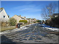
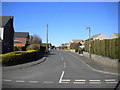
2
High Lane - viewed from Vicar Park Drive
Image: © Betty Longbottom
Taken: 3 Feb 2015
0.04 miles
5
High Lane, Norton Tower
Off Roils Head Road.
Image: © Richard Vince
Taken: 10 Apr 2019
0.07 miles
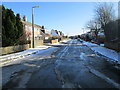
6
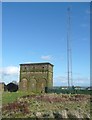
Tower and radio mast, Roils Head Reservoir, Warley (Halifax)
This was taken from Warley Common. The old boundary between Warley and Ovenden goes past the northern side of the reservoir and the round-headed stone post to the left of the tower might be a boundary stone (or maybe just a gate-post). The old spelling (1907 and before) of 'Roils' was 'Royles'.
Image: © Humphrey Bolton
Taken: 26 Mar 2009
0.07 miles
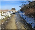
9
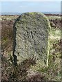
Boundary Stone, Warley Common
Image: © Humphrey Bolton
Taken: 2 Apr 2009
0.07 miles
10
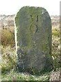
Boundary Stone, Ovenden
This is one of the two out of a large number of boundary stones that were placed along the boundary between Ovenden and Warley sometime before 1850. This one is numbered VI on the Ovenden side, which might indicate that the stones were erected by Ovenden Township. The other one at Balkram Edge is numbered XIV (see Image).
Image: © Humphrey Bolton
Taken: 2 Apr 2009
0.07 miles