IMAGES TAKEN NEAR TO
Spring Edge, HALIFAX, HX1 3BB
Introduction
This page details the photographs taken nearby to Spring Edge, HX1 3BB by members of the Geograph project.
The Geograph project started in 2005 with the aim of publishing, organising and preserving representative images for every square kilometre of Great Britain, Ireland and the Isle of Man.

There are currently over 7.5m images from over14,400 individuals and you can help contribute to the project by visiting https://www.geograph.org.uk
Image Map (Loading...)


Getting Data...Please wait
Leaflet Map data © OpenStreetMap
Images are licensed for reuse under creativecommons.org/licenses/by-sa/2.0
Notes
- Clicking on the map will re-center to the selected point.
- The higher the marker number, the further away the image location is from the centre of the postcode.
Image Listing (304 Images Found)
Images are licensed for reuse under creativecommons.org/licenses/by-sa/2.0
Image
Details
Distance
3
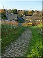
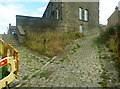
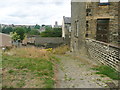
Setted path to Spring Edge
The path, shown as a public right of way on the OS map, probably dates back to the 19th century and connects the streets of housing accessed from Savile Park with those at a lower level in the Spring Edge area accessed from King Cross.
Image: © Stephen Craven
Taken: 12 Nov 2022
0.06 miles
4
Halifax Community Fire Station - Skircoat Moor Road, Halifax
Image: © Betty Longbottom
Taken: 20 Feb 2008
0.06 miles
5
Spring Edge South - Free School Lane
Image: © Betty Longbottom
Taken: 6 Jul 2009
0.06 miles
6
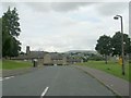
Halifax FP666, Skircoat
The steps on the left lead to Eldroth Road.
Image: © Humphrey Bolton
Taken: 2 Aug 2018
0.07 miles
7
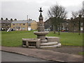
Fountain with troughs on Spring Edge South
Image: © Alexander P Kapp
Taken: 16 Dec 2008
0.07 miles
8
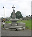
Fountain - Spring Edge South
Erected in 1884.
Image: © Betty Longbottom
Taken: 6 Jul 2009
0.07 miles
9
Halifax FP666, Skircoat
Halifax FP667 is a short path to the right, leading to Eldroth Road via Back Eldroth Road. There are also steps to the end of Eldroth Road to the right of the yellow roadworks barrier.
Image: © Humphrey Bolton
Taken: 2 Aug 2018
0.07 miles