IMAGES TAKEN NEAR TO
Clover Hill Road, HALIFAX, HX1 2YW
Introduction
This page details the photographs taken nearby to Clover Hill Road, HX1 2YW by members of the Geograph project.
The Geograph project started in 2005 with the aim of publishing, organising and preserving representative images for every square kilometre of Great Britain, Ireland and the Isle of Man.

There are currently over 7.5m images from over14,400 individuals and you can help contribute to the project by visiting https://www.geograph.org.uk
Image Map
Images are licensed for reuse under creativecommons.org/licenses/by-sa/2.0
Notes
- Clicking on the map will re-center to the selected point.
- The higher the marker number, the further away the image location is from the centre of the postcode.
Image Listing (138 Images Found)
Images are licensed for reuse under creativecommons.org/licenses/by-sa/2.0
Image
Details
Distance
1
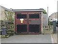
Electricity Substation No 2013 - Clover Hill Road
Image: © Betty Longbottom
Taken: 7 Oct 2013
0.01 miles
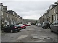
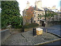
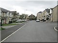
3
Clover Hill Road at Glen View Terrace, Skircoat, Halifax
Clover Hill Road is on the 1850 six-inch map. It now ends at the right turn beyond the parked car, where the house called Clover Hill used to be, the lane continued to Halifax. It is now a footpath. going past the tree.
Image: © Humphrey Bolton
Taken: 4 Nov 2016
0.01 miles
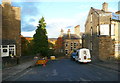
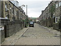
5
At the end of Clover Hill Road, Skircoat, Halifax
The street to the right is Back Glen View Terrace. Clover Hill was four houses to the right, and was shown on the 1893 1:2500 map but not on the 1905 edition; it made way for late 19C terrace houses. The broad paved footpath on the left goes to Well Head Lane, towards the centre of Halifax.
Image: © Humphrey Bolton
Taken: 4 Nov 2016
0.02 miles
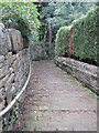
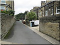
8
Clover Hill Walk, Skircoat, Halifax
This is an old lane, shown on the 1850 six-inch map. It is an adopted highway with bollards to prevent cars from using it, but is not a public footpath. This is the steep descent from the end of Clover Hill Road.
Image: © Humphrey Bolton
Taken: 4 Nov 2016
0.05 miles
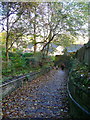
9

Trees off Clover Hill Road, Skircoat, Halifax
The building behind is indoor tennis courts.
Image: © Humphrey Bolton
Taken: 4 Nov 2016
0.05 miles
10
Hastings Way - looking towards Free School Lane
Image: © Betty Longbottom
Taken: 7 Oct 2013
0.05 miles