IMAGES TAKEN NEAR TO
Wingfield Road, HULL, HU9 4QD
Introduction
This page details the photographs taken nearby to Wingfield Road, HU9 4QD by members of the Geograph project.
The Geograph project started in 2005 with the aim of publishing, organising and preserving representative images for every square kilometre of Great Britain, Ireland and the Isle of Man.

There are currently over 7.5m images from over14,400 individuals and you can help contribute to the project by visiting https://www.geograph.org.uk
Image Map
Images are licensed for reuse under creativecommons.org/licenses/by-sa/2.0
Notes
- Clicking on the map will re-center to the selected point.
- The higher the marker number, the further away the image location is from the centre of the postcode.
Image Listing (181 Images Found)
Images are licensed for reuse under creativecommons.org/licenses/by-sa/2.0
Image
Details
Distance
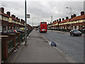
5
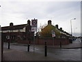
Wingfield Road at Shelley Avenue, Sutton Trust Estate
Image: © Ian S
Taken: 13 Nov 2012
0.05 miles
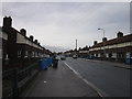
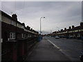
7
Shelley Avenue towards Wingfield Road, Hull
Sutton Trust Estate.
Image: © Ian S
Taken: 1 Nov 2013
0.05 miles
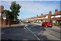
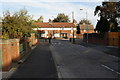
9
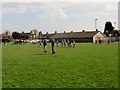
Shelley Avenue Playing field East Hull
Two Hull Sunday League Under 12 teams preparing for a match. The long low building is the changing rooms and facilities.The car park and entrance from Shelley Avenue is to its left
Image: © Martin Dawes
Taken: 22 Apr 2018
0.06 miles
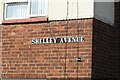
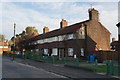
10
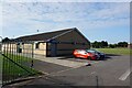
William Sutton Trust Sports Centre
On Shelley Avenue, Hull.
Image: © Ian S
Taken: 16 Sep 2021
0.06 miles