
IMAGES TAKEN NEAR TO
South Bridge Road, HULL, HU9 1TR
Introduction
This page details the photographs taken nearby to South Bridge Road, HU9 1TR by members of the Geograph project.
The Geograph project started in 2005 with the aim of publishing, organising and preserving representative images for every square kilometre of Great Britain, Ireland and the Isle of Man.

There are currently over 7.5m images from over14,400 individuals and you can help contribute to the project by visiting https://www.geograph.org.uk
Image Map
Images are licensed for reuse under creativecommons.org/licenses/by-sa/2.0
Notes
- Clicking on the map will re-center to the selected point.
- The higher the marker number, the further away the image location is from the centre of the postcode.
Image Listing (490 Images Found)
Images are licensed for reuse under creativecommons.org/licenses/by-sa/2.0
Image
Details
Distance

2

Victoria Dock Village, Kingston upon Hull
At left, dwellings at Axeholme Court, adjacent to the lock pit between the Outer Basin and the Half-Tide Basin, the former Victoria Dock. At rear, housing in South Bridge Road.
Image: © Bernard Sharp
Taken: 11 Aug 2013
0.03 miles
3

Victoria Dock, Kingston upon Hull
Shed, north side of South Bridge Road and west of the lock pit.
Image: © Bernard Sharp
Taken: 12 Jun 1983
0.03 miles
4

Victoria Park, Hull
With the sundial shown at Image A view from South Bridge Road.
Image: © Derek Harper
Taken: 3 Jan 2012
0.03 miles
5
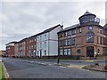
South Bridge Road, Kingston upon Hull
Sequana Court, Nos.84 to 106 South Bridge Road, and the Victoria Dock Company offices, Victoria Dock Village.
Victoria Dock opened 1850 and closed to commercial traffic 1970. The following year the dock, except for the half-tide basin, was filled in. In 1987 the City Council acquired the dock estate from ABP (Associated British Ports). The same year, the Council entered into a partnership with Bellway Homes Ltd to redevelop the estate for new homes, a marina, a park, playing fields, community centre, maritime museum and community school. House-building commenced in 1988.
Image: © Bernard Sharp
Taken: 25 Oct 2014
0.04 miles

7

Sequana Court, Kingston upon Hull
On the north side of the Half-tide Basin, the former Victoria Dock, apartments at Nos.1 to 8 and 9 to 17 Sequana Court, Victoria Dock Village.
Victoria Dock opened 1850 and closed to commercial traffic 1970. The following year the dock, except for the half-tide basin, was filled in. In 1987 the City Council acquired the dock estate from ABP (Associated British Ports). The same year, the Council entered into a partnership with Bellway Homes Ltd to redevelop the estate for new homes, a marina, a park, playing fields, community centre, maritime museum and community school. House-building commenced in 1988.
Image: © Bernard Sharp
Taken: 25 Oct 2014
0.04 miles
8

South Bridge Road, Kingston upon Hull
Dwellings in South Bridge Road reflected in the Half-Tide Basin, former Victoria Dock.
Image: © Bernard Sharp
Taken: 6 Jun 2021
0.04 miles
9

South Bridge Road, Kingston upon Hull
Dwellings in South Bridge Road reflected in the Half-Tide Basin, former Victoria Dock. Viewed from the lock-pit connecting to the Outer Basin.
Image: © Bernard Sharp
Taken: 6 Jun 2021
0.04 miles
