IMAGES TAKEN NEAR TO
Henley Avenue, Brazil Street, HULL, HU9 1JU
Introduction
This page details the photographs taken nearby to Henley Avenue, Brazil Street, HU9 1JU by members of the Geograph project.
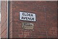
The Geograph project started in 2005 with the aim of publishing, organising and preserving representative images for every square kilometre of Great Britain, Ireland and the Isle of Man.

There are currently over 7.5m images from over14,400 individuals and you can help contribute to the project by visiting https://www.geograph.org.uk
Image Map
Images are licensed for reuse under creativecommons.org/licenses/by-sa/2.0
Notes
- Clicking on the map will re-center to the selected point.
- The higher the marker number, the further away the image location is from the centre of the postcode.
Image Listing (376 Images Found)
Images are licensed for reuse under creativecommons.org/licenses/by-sa/2.0
Image
Details
Distance
1
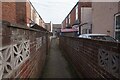
Henley Avenue off Brazil Street, Hull
https://www.geograph.org.uk/photo/6770818
Image: © Ian S
Taken: 25 Feb 2021
0.01 miles
2
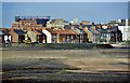
Abbey Street, Kingston upon Hull
The west side of Abbey Street, centre foreground, with Reckitt's factory complex, Dansom Lane, and the gasholder, St Mark's Street, background. The land in the immediate foreground had been cleared for the construction of (a) Mount Pleasant, a new road linking Holderness Road with Hedon Road, and (b) The Mount Retail Park. Viewed from the bridge, Southcoates Lane.
Image: © Bernard Sharp
Taken: 15 Aug 1986
0.02 miles
3
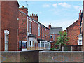
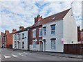
Abbey Street, Kingston upon Hull
Between Nos.111 & 113 Abbey Street, Elder Avenue, a court or terrace of eight dwellings; depicted are Nos.1 to 4.
Image: © Bernard Sharp
Taken: 9 Jun 2014
0.02 miles
4
Elder Avenue off Abbey Street, Hull
https://www.geograph.org.uk/photo/6770794
Image: © Ian S
Taken: 25 Feb 2021
0.02 miles
5

Henley Avenue off Brazil Street, Hull
https://www.geograph.org.uk/photo/6770816
Image: © Ian S
Taken: 25 Feb 2021
0.02 miles
6
Elder Avenue off Abbey Street, Hull
https://www.geograph.org.uk/photo/6770789
Image: © Ian S
Taken: 25 Feb 2021
0.02 miles
8

Brentwood Avenue off Brazil Street, Hull
https://www.geograph.org.uk/photo/6770811
Image: © Ian S
Taken: 25 Feb 2021
0.02 miles
9
Brazil Street, Kingston upon Hull
Nos.5 to 59 Brazil Street. No.5 is business use (former house?), the rest are residential. Brazil Street was laid out 1893.
Image: © Bernard Sharp
Taken: 11 Jun 2014
0.02 miles
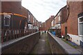
10
Brazil Street, Kingston upon Hull
Between Brentwood Villas and Eastern Villas, Nos.37 to 43 Brazil Street, semi-detached houses. The street was laid out in 1893.
Image: © Bernard Sharp
Taken: 9 Jun 2014
0.03 miles