IMAGES TAKEN NEAR TO
Callow Hill Drive, HULL, HU7 4ZL
Introduction
This page details the photographs taken nearby to Callow Hill Drive, HU7 4ZL by members of the Geograph project.
The Geograph project started in 2005 with the aim of publishing, organising and preserving representative images for every square kilometre of Great Britain, Ireland and the Isle of Man.

There are currently over 7.5m images from over14,400 individuals and you can help contribute to the project by visiting https://www.geograph.org.uk
Image Map
Images are licensed for reuse under creativecommons.org/licenses/by-sa/2.0
Notes
- Clicking on the map will re-center to the selected point.
- The higher the marker number, the further away the image location is from the centre of the postcode.
Image Listing (99 Images Found)
Images are licensed for reuse under creativecommons.org/licenses/by-sa/2.0
Image
Details
Distance

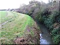
2

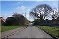
Castle Hill Road, Kingston upon Hull
Castle Hill Road between Noddle Hill Way and Sutton Cross Drain, at which point there is a gate with a 'private road' notice thereon. The continuation of the road leads to Castle Hill ancient monument.
Image: © Bernard Sharp
Taken: 1 Mar 2012
0.07 miles
3
Castle Hill Aquagreen, Kingston upon Hull
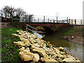
The Holderness Drain Flood Alleviation Scheme involves work at two sites, one of which is the creation of an aquagreen (flood storage area) at Castle Hill. Work is due to be completed by Spring 2024. Full details of the project, managed by the Environment Agency: https://consult.environment-agency.gov.uk/yorkshire/holderness-drain-flood-alleviation-scheme/ Depicted is the swale extending between Castle Hill Road and the Trans Pennine Trail (former Hornsea branch railway). Looking towards the road bridge, Castle Hill Road. Beyond the bridge, the watercourse continues as Sutton Cross Drain.
Image: © Bernard Sharp
Taken: 7 Mar 2024
0.07 miles
4
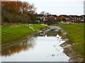
Castle Hill Aquagreen, Kingston upon Hull
The Holderness Drain Flood Alleviation Scheme involves work at two sites, one of which is the creation of an aquagreen (flood storage area) at Castle Hill. Work is due to be completed by Spring 2024. Full details of the project, managed by the Environment Agency: https://consult.environment-agency.gov.uk/yorkshire/holderness-drain-flood-alleviation-scheme/ Depicted is the swale extending between the Trans Pennine Trail (former Hornsea branch railway) and Castle Hill Road. Alongside the road bridge is a kissing-gate for pedestrian use.
Image: © Bernard Sharp
Taken: 29 Feb 2024
0.08 miles
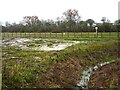
5
Castle Hill Aquagreen, Kingston upon Hull
The Holderness Drain Flood Alleviation Scheme involves work at two sites, one of which is the creation of an aquagreen (flood storage area) at Castle Hill. Work is due to be completed by Spring 2024. Full details of the project, managed by the Environment Agency: https://consult.environment-agency.gov.uk/yorkshire/holderness-drain-flood-alleviation-scheme/ Depicted is the swale extending between the Trans Pennine Trail (former Hornsea branch railway) and Castle Hill Road.
Image: © Bernard Sharp
Taken: 29 Feb 2024
0.08 miles
6
Castlehill Road off Noddle Hill Way, Hull
https://www.geograph.org.uk/photo/6782350
Image: © Ian S
Taken: 14 Mar 2021
0.09 miles
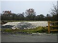
7
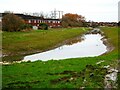
Castle Hill Aquagreen, Kingston upon Hull
The Holderness Drain Flood Alleviation Scheme involves work at two sites, one of which is the creation of an aquagreen (flood storage area) at Castle Hill. Work is due to be completed by Spring 2024. Full details of the project, managed by the Environment Agency: https://consult.environment-agency.gov.uk/yorkshire/holderness-drain-flood-alleviation-scheme/ The contractor's compound is within the fencing on the south side of Castle Hill Road. Work is in abeyance until ground conditions improve. The contractor is expected to be on-site again by April 2024. A meandering drain can be seen roughly following the south side of the road.
Image: © Bernard Sharp
Taken: 7 Mar 2024
0.09 miles
9
Castle Hill Aquagreen, Kingston upon Hull
The Holderness Drain Flood Alleviation Scheme involves work at two sites, one of which is the creation of an aquagreen (flood storage area) at Castle Hill. Work is due to be completed by Spring 2024. Full details of the project, managed by the Environment Agency: https://consult.environment-agency.gov.uk/yorkshire/holderness-drain-flood-alleviation-scheme/ The contractor's compound is within the fencing on the south side of Castle Hill Road. Work is in abeyance until ground conditions improve. The contractor is expected to be on-site again by April 2024.
Image: © Bernard Sharp
Taken: 7 Mar 2024
0.09 miles
10
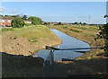
Flood alleviation scheme, Hull
A new body of water, built to store excess water from nearby land and drains to prevent flooding of nearby residential areas. Dubbed the Castlehill Aquagreen, it is part of the £28 million Holderness Drain Flood Alleviation Scheme (FAS) led by the Environment Agency and supported by Hull City Council, East Riding of Yorkshire Council, Highways England and the Humber Local Enterprise Partnership. https://consult.environment-agency.gov.uk/yorkshire/holderness-drain-flood-alleviation-scheme/user_uploads/castlehill-consultation-summary-of-findings-final.pdf
Image: © Paul Harrop
Taken: 4 Jul 2023
0.09 miles