IMAGES TAKEN NEAR TO
Highfield Close, HULL, HU7 4UA
Introduction
This page details the photographs taken nearby to Highfield Close, HU7 4UA by members of the Geograph project.
The Geograph project started in 2005 with the aim of publishing, organising and preserving representative images for every square kilometre of Great Britain, Ireland and the Isle of Man.

There are currently over 7.5m images from over14,400 individuals and you can help contribute to the project by visiting https://www.geograph.org.uk
Image Map
Images are licensed for reuse under creativecommons.org/licenses/by-sa/2.0
Notes
- Clicking on the map will re-center to the selected point.
- The higher the marker number, the further away the image location is from the centre of the postcode.
Image Listing (427 Images Found)
Images are licensed for reuse under creativecommons.org/licenses/by-sa/2.0
Image
Details
Distance
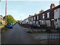
1
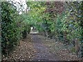
Sutton Trod, Kingston upon Hull
Sutton Trod may have been an ancient footpath between the adjoining parishes of Sutton on Hull and Drypool. The vegetation on either side of the path largely comprises hawthorn, ash, elder, ivy, horse chestnut, sycamore and snowberry.
Illustrated is the section between Tweendykes Road and Chamberlain Street, looking north.
Image: © Bernard Sharp
Taken: 25 Oct 2017
0.03 miles
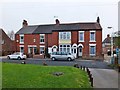
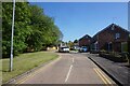
2
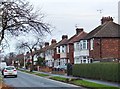
Highfield, Kingston upon Hull
Houses on the east side of the street.
Image: © Bernard Sharp
Taken: 30 Nov 2013
0.05 miles
3
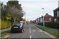
Highfield off Tween Dykes Road, Hull
https://www.geograph.org.uk/photo/6797616
Image: © Ian S
Taken: 29 Mar 2021
0.05 miles
4
Watson Street, Sutton on Hull, Yorkshire
Nos.31 & 33 Watson Street, accessed via a private road to the west of No.29.
Image: © Bernard Sharp
Taken: 25 Apr 2013
0.06 miles
5
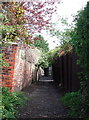
The Church Path, Sutton
Approaching the northern end of the long alleyway between Tween Dykes Road and Chamberlain Street, Sutton on Hull.
Image: © Paul Glazzard
Taken: 21 Apr 2008
0.06 miles
6
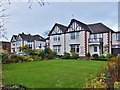
Tweendykes Road, Kingston upon Hull
Nos.80 & 82 and 76 & 78 Tweendykes Road, two similar pairs of semi-detached houses with first floor balconies and mock-Tudor gables.
Image: © Bernard Sharp
Taken: 30 Nov 2013
0.06 miles
7
Watson Street, Sutton on Hull, Yorkshire
Nos.23 Ivy Cottage, 25 Cosey Cottage, 27 & 29 Watson Street.
Image: © Bernard Sharp
Taken: 25 Apr 2013
0.07 miles

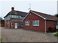
10
Overstrand Drive off Tween Dykes Road, Hull
https://www.geograph.org.uk/photo/6866927
Image: © Ian S
Taken: 5 Jun 2021
0.08 miles