IMAGES TAKEN NEAR TO
Highfield Close, HULL, HU7 4TZ
Introduction
This page details the photographs taken nearby to Highfield Close, HU7 4TZ by members of the Geograph project.
The Geograph project started in 2005 with the aim of publishing, organising and preserving representative images for every square kilometre of Great Britain, Ireland and the Isle of Man.

There are currently over 7.5m images from over14,400 individuals and you can help contribute to the project by visiting https://www.geograph.org.uk
Image Map
Images are licensed for reuse under creativecommons.org/licenses/by-sa/2.0
Notes
- Clicking on the map will re-center to the selected point.
- The higher the marker number, the further away the image location is from the centre of the postcode.
Image Listing (475 Images Found)
Images are licensed for reuse under creativecommons.org/licenses/by-sa/2.0
Image
Details
Distance
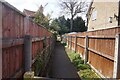
1
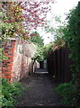
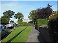
The Church Path, Sutton
Approaching the northern end of the long alleyway between Tween Dykes Road and Chamberlain Street, Sutton on Hull.
Image: © Paul Glazzard
Taken: 21 Apr 2008
0.03 miles
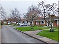
2
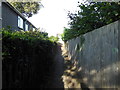
A path leading to Chamberlain Street, Sutton on Hull
Image: © Ian S
Taken: 28 Sep 2013
0.03 miles
3
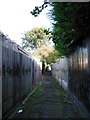
A path leading to Chamberlain Street, Sutton on Hull
Image: © Ian S
Taken: 28 Sep 2013
0.03 miles
4
A path leading to Chamberlain Street, Sutton on Hull
Image: © Ian S
Taken: 28 Sep 2013
0.05 miles
5
Sutton Trod off Chamberlain Street, Sutton, Hull
https://www.geograph.org.uk/photo/6831094
Image: © Ian S
Taken: 30 Apr 2021
0.05 miles
6
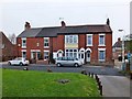
Watson Street, Sutton on Hull, Yorkshire
Nos.23 Ivy Cottage, 25 Cosey Cottage, 27 & 29 Watson Street.
Image: © Bernard Sharp
Taken: 25 Apr 2013
0.05 miles
7
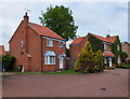
Chamberlain Street, Sutton on Hull, Yorkshire
Nos.6 & 7 Hornbeams Court.
Image: © Bernard Sharp
Taken: 17 May 2013
0.05 miles
8
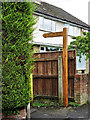
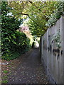
Sutton Trod, Kingston upon Hull
Sutton Trod may have been an ancient footpath between the adjoining parishes of Sutton on Hull and Drypool. The vegetation on either side of the path largely comprises hawthorn, ash, elder, ivy, horse chestnut, sycamore and snowberry.
In 2019, wayfinding posts were erected at either end of the trod, inscribed 'SUTTON TROD C11 ANCIENT PATH'. Illustrated is the post at Chamberlain Street. They were manufactured by Woodcraft UK, whose website provides details about the commissioning: https://www.woodcraftuk.co.uk/news/2019/wayfinding-posts-for-sutton-trod-in-yorkshire
Image: © Bernard Sharp
Taken: 2 Jul 2020
0.05 miles
9
A path leading to Chamberlain Street, Sutton on Hull
Image: © Ian S
Taken: 28 Sep 2013
0.05 miles
10
Chamberlain Street, Sutton on Hull, Yorkshire
Nos.30 to 39 Chamberlain Street, erected 1974, partly to provide additional accommodation and partly to replace homes in Barker's Entry, High Street, Kingston upon Hull, destroyed by enemy action in 1941. Funded by the Leonard Chamberlain Trust, founded 1716, when he left money in his will for almshouses in Sutton on Hull.
Image: © Bernard Sharp
Taken: 25 Apr 2013
0.05 miles