
IMAGES TAKEN NEAR TO
Church Street, HULL, HU7 4TT
Introduction
This page details the photographs taken nearby to Church Street, HU7 4TT by members of the Geograph project.
The Geograph project started in 2005 with the aim of publishing, organising and preserving representative images for every square kilometre of Great Britain, Ireland and the Isle of Man.

There are currently over 7.5m images from over14,400 individuals and you can help contribute to the project by visiting https://www.geograph.org.uk
Image Map
Images are licensed for reuse under creativecommons.org/licenses/by-sa/2.0
Notes
- Clicking on the map will re-center to the selected point.
- The higher the marker number, the further away the image location is from the centre of the postcode.
Image Listing (312 Images Found)
Images are licensed for reuse under creativecommons.org/licenses/by-sa/2.0
Image
Details
Distance
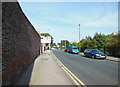
2
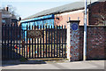
Alternative Heritage Blue Plaque
On Church Street, Sutton. Only in Hull can we celebrate a road rage bully like Ronnie Pickering. More alternative blue plaques can be found here, https://www.geograph.org.uk/tagged/alternative+heritage+blue+plaque#photo=6066836
Image: © Ian S
Taken: 24 Mar 2019
0.00 miles
3
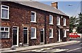
Church Street, Sutton on Hull, Yorkshire
At the junction with Leads Road, Nos.2, 4 & 6 Church Street, a terrace of three Victorian houses. No.2 (right), a surgery, was formerly a police station, with cells in the back yard. The entire terrace is being refurbished in 2013, with access through the courtyard in Leads Road. See also: Image
Image: © Bernard Sharp
Taken: 15 Jul 1990
0.01 miles
4
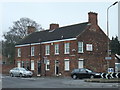
Church Street, Sutton on Hull, Yorkshire
At the junction with Leads Road, Nos.2, 4 & 6 Church Street, a terrace of three Victorian houses. No.2 (right) was formerly a police station, with cells in the back yard; subsequently a surgery. A notice on the gable end states: "Due to relocation to new purpose-built facility FOR SALE ......." The entire terrace is being refurbished in 2013, with access through the courtyard in Leads Road. See also: Image
Image: © Bernard Sharp
Taken: 17 Mar 2011
0.01 miles
5
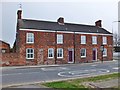
Church Street, Sutton on Hull, Yorkshire
At the junction with Leads Road, Nos.2, 4 & 6 Church Street, a terrace of three Victorian houses. No.2 (right) was formerly a police station, with cells in the back yard; subsequently a surgery. The entire terrace is currently being refurbished, with access through the courtyard in Leads Road.
Image: © Bernard Sharp
Taken: 25 Apr 2013
0.01 miles
6
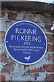
Alternative Heritage Blue Plaque
On Church Street, Sutton. Only in Hull can we celebrate a road rage bully like Ronnie Pickering. More alternative blue plaques can be found here, https://www.geograph.org.uk/tagged/alternative+heritage+blue+plaque#photo=6066836
Image: © Ian S
Taken: 24 Mar 2019
0.01 miles
7
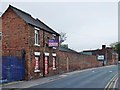
Church Street, Sutton on Hull, Yorkshire
At left, the two-storey building at No.16 is part of a former antiques and reclamation business. Behind the wall is the Victorian 'Mona House', part of the site occupied by the 4th Battalion, The Yorkshire Regiment. At the far end, a terrace of three Victorian houses, Nos.2, 4 & 6 Church Street.
Image: © Bernard Sharp
Taken: 25 Apr 2013
0.02 miles
8
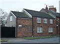
Leads Road, Sutton on Hull, Yorkshire
The Old Forge Cottage, No.2A Leads Road.
Image: © Bernard Sharp
Taken: 17 Mar 2011
0.02 miles

10
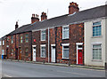
West Parade, Leads Road, Sutton on Hull, Yorkshire
Nos.1 to 4 West Parade.
Image: © Bernard Sharp
Taken: 25 Apr 2013
0.03 miles