IMAGES TAKEN NEAR TO
Mount Pleasant, HULL, HU7 4TH
Introduction
This page details the photographs taken nearby to Mount Pleasant, HU7 4TH by members of the Geograph project.
The Geograph project started in 2005 with the aim of publishing, organising and preserving representative images for every square kilometre of Great Britain, Ireland and the Isle of Man.

There are currently over 7.5m images from over14,400 individuals and you can help contribute to the project by visiting https://www.geograph.org.uk
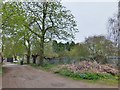
Image Map
Images are licensed for reuse under creativecommons.org/licenses/by-sa/2.0
Notes
- Clicking on the map will re-center to the selected point.
- The higher the marker number, the further away the image location is from the centre of the postcode.
Image Listing (432 Images Found)
Images are licensed for reuse under creativecommons.org/licenses/by-sa/2.0
Image
Details
Distance
1

Church Street, Sutton on Hull, Yorkshire
Mount Pleasant, a terrace of five houses, extant by 1890, situated to the east of Church Mount. Access from Church Street, via the drive between Nos.7 & 8 Church Mount. Viewed from the amenity area adjacent to Robson Way.
Image: © Bernard Sharp
Taken: 6 May 2013
0.01 miles
2

Church Street, Sutton on Hull, Yorkshire
Mount Pleasant, a terrace of five houses, extant by 1890, situated to the east of Church Mount. Access from Church Street, via the drive between Nos.7 & 8 Church Mount. Rear of the properties, viewed from the amenity area adjacent to Robson Way.
Image: © Bernard Sharp
Taken: 13 Dec 2013
0.01 miles

4
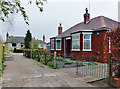
Church Close, Sutton on Hull, Yorkshire
A mid-20th century development of three bungalows between Church Mount and No.53 Church Street.
Image: © Bernard Sharp
Taken: 25 Apr 2013
0.04 miles
5
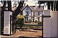
Church Mount, Church Street, Sutton on Hull, Yorkshire
Church Mount, a speculative development of twelve gabled villas, built 1865-1870 for jeweller Thomas Kirk of Kingston upon Hull. Depicted is No.12, Westerdale House.
See also: Image
Image: © Bernard Sharp
Taken: 15 Jul 1990
0.05 miles
6

Redbricks and Slate, Sutton-on-Hull
A pair of these splendid buildings stand well back from the main road through Sutton. The map also reveals that they have as much land at the back as they do at the front (as per photograph).
Image: © Peter Church
Taken: 16 Feb 2008
0.05 miles
7

Church Mount, Church Street, Sutton on Hull, Yorkshire
Church Mount, a speculative development of twelve gabled villas, built 1865-1870 for jeweller Thomas Kirk of Kingston upon Hull. Depicted is No.12, Westerdale House.
Image: © Bernard Sharp
Taken: 25 Apr 2013
0.05 miles
8
Church Street, Sutton on Hull, Yorkshire
Church Mount, a speculative development of twelve gabled villas, built 1865-1870 for jeweller Thomas Kirk of Kingston upon Hull. Depicted is No.12, Westerdale House.
Image: © Bernard Sharp
Taken: 17 May 2013
0.05 miles
9
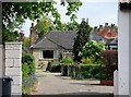
Church Close, Sutton on Hull, Yorkshire
A mid-20th century development of three bungalows between Church Mount and No.53 Church Street.
Image: © Bernard Sharp
Taken: 28 Apr 2011
0.05 miles
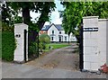
10
Church Mount, Church Street, Sutton on Hull, Yorkshire
The access road to the rear of the houses in Church Mount.
Image: © Bernard Sharp
Taken: 25 Apr 2013
0.06 miles