IMAGES TAKEN NEAR TO
Park Walk, Church Street, HULL, HU7 4PD
Introduction
This page details the photographs taken nearby to Park Walk, Church Street, HU7 4PD by members of the Geograph project.
The Geograph project started in 2005 with the aim of publishing, organising and preserving representative images for every square kilometre of Great Britain, Ireland and the Isle of Man.

There are currently over 7.5m images from over14,400 individuals and you can help contribute to the project by visiting https://www.geograph.org.uk
Image Map
Images are licensed for reuse under creativecommons.org/licenses/by-sa/2.0
Notes
- Clicking on the map will re-center to the selected point.
- The higher the marker number, the further away the image location is from the centre of the postcode.
Image Listing (353 Images Found)
Images are licensed for reuse under creativecommons.org/licenses/by-sa/2.0
Image
Details
Distance
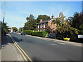
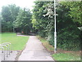
1
Church Street, Sutton on Hull, Yorkshire
Adjacent to Park Walk, a gated private road, No.19 Church Street, a dwelling house, formerly the railway station house, Kingston upon Hull to Hornsea Branch Railway.
Image: © Bernard Sharp
Taken: 25 Apr 2013
0.00 miles
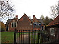
3
Sutton on Hull railway station (site), Yorkshire
Opened in 1864 by the Hull & Hornsea Railway, which soon to become part of the North Eastern Railway empire, this station closed to passengers in 1964 and completely in 1965. View south east towards Hull.
The path is located between the former platforms but the trackbed appears to have been filled in to platform height. The path on the left leads up to the former Station Master's house. Barely visible in the trees is the Church Street road overbridge.
Image: © Nigel Thompson
Taken: 12 Jul 2009
0.01 miles
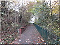
4
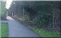
The Trans Pennine Trail
This is part of the (disused) Hull to Hornsea Railway line and also marked on the OS maps as the Hornsea Rail Trail.
Image: © Peter Church
Taken: 6 Jan 2008
0.02 miles
5
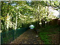
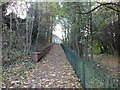
This was the way to Sutton Railway Station
The trackbed is now part of the Trans Pennine Trail.
Image: © Ian S
Taken: 27 Oct 2010
0.02 miles
6
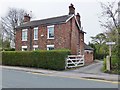
Church Street, Sutton on Hull, Yorkshire
Footpath, to the west of No.19 Church Street, leading to the Trans Pennine Trail, the former Hornsea Branch Railway. This is part of Public Right of Way No.13, extending 170 metres between Church Street and Robson Way.
Image: © Bernard Sharp
Taken: 25 Apr 2013
0.02 miles
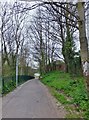
7
Path up to Church Street
The Hornsea Rail Trail on the right.
Image: © Jonathan Thacker
Taken: 7 Nov 2015
0.02 miles
8
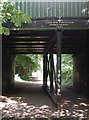
The Hull & Hornsea Railway
Cast iron bridge over the Hull & Hornsea Railway at Church Street, Sutton on Hull, manufactured in 1863 at the Phoenix Foundry in York.
In 1846 the York & North Midland Railway Co. was granted permission to build a line from Beverley to Hornsea, and in 1861 Joseph Armytage Wade promoted the building of a line from Hornsea to Hull and the Hull & Hornsea Railway Co. was formed. The line opened in 1864 but after little or no financial success the company merged with North Eastern Railway in 1866. The terminus at the seafront in Hornsea closed in 1964 and the nearby Hornsea Bridge Station the following year. Hornsea Bridge Station has been demolished and the seafront terminus converted into housing.
The disused railway line now forms the Hornsea Rail Trail and the eastern stretch of the Trans Pennine Trail. The Trans Pennine Trail runs for 215 miles from Hornsea to Southport and was officially opened in September 2001.
Image: © Paul Glazzard
Taken: 23 Aug 2007
0.02 miles