IMAGES TAKEN NEAR TO
Memory Lane, HULL, HU7 3LP
Introduction
This page details the photographs taken nearby to Memory Lane, HU7 3LP by members of the Geograph project.
The Geograph project started in 2005 with the aim of publishing, organising and preserving representative images for every square kilometre of Great Britain, Ireland and the Isle of Man.

There are currently over 7.5m images from over14,400 individuals and you can help contribute to the project by visiting https://www.geograph.org.uk
Image Map
Images are licensed for reuse under creativecommons.org/licenses/by-sa/2.0
Notes
- Clicking on the map will re-center to the selected point.
- The higher the marker number, the further away the image location is from the centre of the postcode.
Image Listing (55 Images Found)
Images are licensed for reuse under creativecommons.org/licenses/by-sa/2.0
Image
Details
Distance
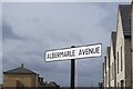
1
Albermarle Avenue, Kingswood, Hull
https://www.geograph.org.uk/photo/6779573
Image: © Ian S
Taken: 14 Mar 2021
0.04 miles
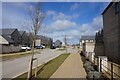
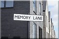
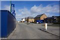
2
Memory Lane, Kingswood, Hull
https://www.geograph.org.uk/photo/6779584
Image: © Ian S
Taken: 14 Mar 2021
0.05 miles
3
Albermarle Avenue, Kingswood, Hull
https://www.geograph.org.uk/photo/6779569
Image: © Ian S
Taken: 14 Mar 2021
0.06 miles
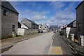
4
Memory Lane, Kingswood, Hull
https://www.geograph.org.uk/photo/6779580
Image: © Ian S
Taken: 14 Mar 2021
0.07 miles
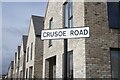
5
Crusoe Road, Kingswood, Hull
https://www.geograph.org.uk/photo/6779559
Image: © Ian S
Taken: 14 Mar 2021
0.08 miles
6
Crusoe Road, Kingswood, Hull
https://www.geograph.org.uk/photo/6779557
Image: © Ian S
Taken: 14 Mar 2021
0.08 miles
7

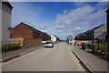
House building, Kingswood, Hull
Part of the large housing development dubbed Kingfields Park by builders Keepmoat https://www.keepmoat.com/development/kingfields-park-hull . The 750-home eastward extension of the Kingswood area on the city's northern boundary was approved in 2016. It is part of a 10-year programme comprising an eventual total of over 1,600 homes.
Image: © Paul Harrop
Taken: 22 Feb 2019
0.09 miles
8
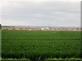
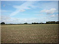
Over South Field toward Kingswood
The ever expanding housing at Kingswood can be seen in the distance all on a floodplain with a bend of the tidal River Hull behind them.
Image: © Martin Dawes
Taken: 12 May 2015
0.10 miles
9
Diversity Drive, Kingswood, Hull
https://www.geograph.org.uk/photo/6779592
Image: © Ian S
Taken: 14 Mar 2021
0.12 miles