IMAGES TAKEN NEAR TO
Blackwater Way, HULL, HU7 3HF
Introduction
This page details the photographs taken nearby to Blackwater Way, HU7 3HF by members of the Geograph project.
The Geograph project started in 2005 with the aim of publishing, organising and preserving representative images for every square kilometre of Great Britain, Ireland and the Isle of Man.

There are currently over 7.5m images from over14,400 individuals and you can help contribute to the project by visiting https://www.geograph.org.uk
Image Map
Images are licensed for reuse under creativecommons.org/licenses/by-sa/2.0
Notes
- Clicking on the map will re-center to the selected point.
- The higher the marker number, the further away the image location is from the centre of the postcode.
Image Listing (106 Images Found)
Images are licensed for reuse under creativecommons.org/licenses/by-sa/2.0
Image
Details
Distance
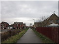
1

A path leading to Kingswood Retail Park, Hull
Near Blackwater Way, Kingswood.
Image: © Ian S
Taken: 8 Jan 2013
0.03 miles
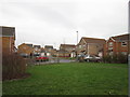
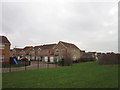

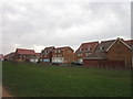
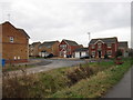
5

Blackwater Way, South Field
Cul-de-sac on the new housing development off Kesteven Way in north Hull. More houses are currently being built just west of here on the south side of Ings Road.
Image: © Paul Glazzard
Taken: 13 Aug 2008
0.04 miles


10
A path next to Charwood Close, Kingswood, Hull
Image: © Ian S
Taken: 8 Jan 2013
0.07 miles