IMAGES TAKEN NEAR TO
Amsterdam Road, HULL, HU7 0XS
Introduction
This page details the photographs taken nearby to Amsterdam Road, HU7 0XS by members of the Geograph project.
The Geograph project started in 2005 with the aim of publishing, organising and preserving representative images for every square kilometre of Great Britain, Ireland and the Isle of Man.

There are currently over 7.5m images from over14,400 individuals and you can help contribute to the project by visiting https://www.geograph.org.uk
Image Map
Images are licensed for reuse under creativecommons.org/licenses/by-sa/2.0
Notes
- Clicking on the map will re-center to the selected point.
- The higher the marker number, the further away the image location is from the centre of the postcode.
Image Listing (126 Images Found)
Images are licensed for reuse under creativecommons.org/licenses/by-sa/2.0
Image
Details
Distance
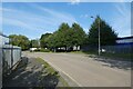
2
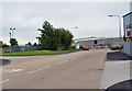
Amsterdam Road
This road is located on Sutton Fields Industrial Estate, and the building at the end houses one of the biggest bakeries in Europe, - Greencore, see http://www.greencore.ie/ for information. If you have ever bought a Christmas cake, it is likely to have been baked here.
Image: © Peter Church
Taken: 2 Jul 2008
0.07 miles
3

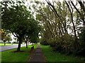
Sutton Road's Cycle Track and Footpath
Looking in an easterly direction.
Image: © Andy Beecroft
Taken: 13 Oct 2008
0.07 miles
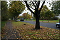
4
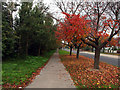
Autumn on Sutton Road
Looking westwards along the footpath just west of Leads Road.
Image: © Andy Beecroft
Taken: 13 Oct 2008
0.08 miles

6
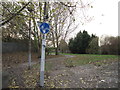
Hamburg Road
Looking along the road where National Cycle Network route 66 crosses.
Image: © DS Pugh
Taken: 2 Sep 2023
0.09 miles

9
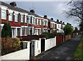
Sutton Road, Hull
Terraced houses on the north side of Sutton Road near the junction of Leads Road. On early 20th century maps these houses are surrounded by open fields.
Image: © Paul Glazzard
Taken: 3 Dec 2007
0.09 miles