IMAGES TAKEN NEAR TO
Foredyke Avenue, HULL, HU7 0DT
Introduction
This page details the photographs taken nearby to Foredyke Avenue, HU7 0DT by members of the Geograph project.
The Geograph project started in 2005 with the aim of publishing, organising and preserving representative images for every square kilometre of Great Britain, Ireland and the Isle of Man.

There are currently over 7.5m images from over14,400 individuals and you can help contribute to the project by visiting https://www.geograph.org.uk
Image Map
Images are licensed for reuse under creativecommons.org/licenses/by-sa/2.0
Notes
- Clicking on the map will re-center to the selected point.
- The higher the marker number, the further away the image location is from the centre of the postcode.
Image Listing (129 Images Found)
Images are licensed for reuse under creativecommons.org/licenses/by-sa/2.0
Image
Details
Distance
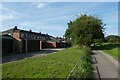
1
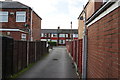
The tenfoot to the rear of Foredyke Avenue, Hull
Image: © Ian S
Taken: 28 Oct 2013
0.01 miles
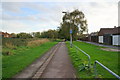
3
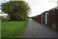
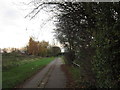
Path behind Foredyke Avenue
The path forms part of National Cycle Network route 66.
Image: © DS Pugh
Taken: 2 Sep 2023
0.02 miles
4
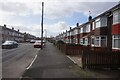
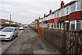
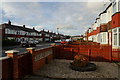
Foredyke Avenue, Hull
https://www.geograph.org.uk/photo/6793233
Image: © Ian S
Taken: 27 Mar 2021
0.02 miles
5
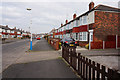
A path leading to Hull City Centre
Houses on Foredyke Avenue.
Image: © Ian S
Taken: 19 Nov 2012
0.02 miles
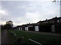
8
A path leading to Hull City Centre
At the rear of Foredyke Avenue
Image: © Ian S
Taken: 19 Nov 2012
0.02 miles