IMAGES TAKEN NEAR TO
Hall Road, HULL, HU6 8SD
Introduction
This page details the photographs taken nearby to Hall Road, HU6 8SD by members of the Geograph project.
The Geograph project started in 2005 with the aim of publishing, organising and preserving representative images for every square kilometre of Great Britain, Ireland and the Isle of Man.

There are currently over 7.5m images from over14,400 individuals and you can help contribute to the project by visiting https://www.geograph.org.uk
Image Map
Images are licensed for reuse under creativecommons.org/licenses/by-sa/2.0
Notes
- Clicking on the map will re-center to the selected point.
- The higher the marker number, the further away the image location is from the centre of the postcode.
Image Listing (102 Images Found)
Images are licensed for reuse under creativecommons.org/licenses/by-sa/2.0
Image
Details
Distance


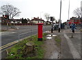
6
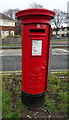
George V postbox on Inglemire Lane, Hull
Image: © JThomas
Taken: 9 Mar 2019
0.05 miles

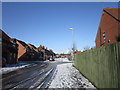
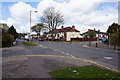
8
Inglemire Lane, Hull
Junction with Hall Road.
Showing position of Postbox No. HU6 185.
See Image] for postbox.
Image: © JThomas
Taken: 9 Mar 2019
0.06 miles
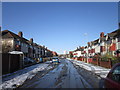
10
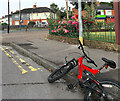
Newbald Grove, Hull
Looking towards Inglemire Lane, close to its junction with Hall Road
Image: © Paul Harrop
Taken: 9 Jul 2023
0.06 miles