IMAGES TAKEN NEAR TO
Hull Road, HULL, HU6 0AS
Introduction
This page details the photographs taken nearby to Hull Road, HU6 0AS by members of the Geograph project.
The Geograph project started in 2005 with the aim of publishing, organising and preserving representative images for every square kilometre of Great Britain, Ireland and the Isle of Man.

There are currently over 7.5m images from over14,400 individuals and you can help contribute to the project by visiting https://www.geograph.org.uk
Image Map
Images are licensed for reuse under creativecommons.org/licenses/by-sa/2.0
Notes
- Clicking on the map will re-center to the selected point.
- The higher the marker number, the further away the image location is from the centre of the postcode.
Image Listing (25 Images Found)
Images are licensed for reuse under creativecommons.org/licenses/by-sa/2.0
Image
Details
Distance
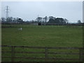
4

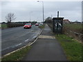
Cycle track beside the A1174
Heading north west towards Beverley.
Image: © JThomas
Taken: 14 Feb 2015
0.09 miles
5
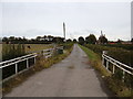
A farm bridge over Barmston Drain near Dunswell
Image: © Ian S
Taken: 22 Dec 2010
0.09 miles


10
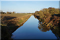
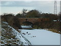
Beverley & Barmston Drain at Dunswell
Taken from Skidby Carr Bridge.
Image: © Ian S
Taken: 27 Dec 2016
0.16 miles