IMAGES TAKEN NEAR TO
Swine Bank, HULL, HU5 5QF
Introduction
This page details the photographs taken nearby to Swine Bank, HU5 5QF by members of the Geograph project.
The Geograph project started in 2005 with the aim of publishing, organising and preserving representative images for every square kilometre of Great Britain, Ireland and the Isle of Man.

There are currently over 7.5m images from over14,400 individuals and you can help contribute to the project by visiting https://www.geograph.org.uk
Image Map
Images are licensed for reuse under creativecommons.org/licenses/by-sa/2.0
Notes
- Clicking on the map will re-center to the selected point.
- The higher the marker number, the further away the image location is from the centre of the postcode.
Image Listing (13 Images Found)
Images are licensed for reuse under creativecommons.org/licenses/by-sa/2.0
Image
Details
Distance
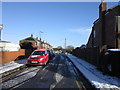
1
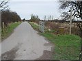
Swine Bank
The metalled track goes as far as Willerby Carr Farm, and then becomes a footpath to Cottingham.
Image: © Peter Church
Taken: 3 Feb 2008
0.08 miles

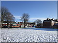
3
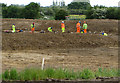
Flood defence work near Hull
Work is being done here to build one of a series of rainwater storage lagoons on former farm land at Willerby Carrs. They form part of the Willerby and Derringham Flood Alleviation Scheme. It is among schemes to reduce the risk of flooding in the Derringham area of Hull and parts of Willerby, following the extensive floods of summer 2007.
The lagoons will resemble flat pasture and most of the time will remain dry, only to be filled during severe wet weather. The £14.4m scheme aims to protect around 8,000 homes, and is due for completion in autumn 2015.
Image: © Paul Harrop
Taken: 1 Jun 2015
0.13 miles
7
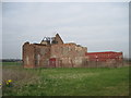
A Derelict Farm with History
A priory for Augustinian canons was founded at Cottingham in 1320 and transferred to this site in 1326. Nothing survives, although the farmhouse incorporates material from the priory. The farm has been derelict for at least 20 years to my knowledge.
Image: © Martin Dawes
Taken: 21 Mar 2012
0.22 miles
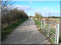
9
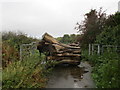
Obstruction on Carr Lane
The gate has been deemed inadequate so this tree stump has been placed to prevent vehicular use of Carr lane.
Image: © Jonathan Thacker
Taken: 14 Oct 2014
0.24 miles
10
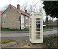
K6 telephone box on Wymersley Road, Hull
See Image] for context.
Image: © JThomas
Taken: 1 Mar 2019
0.24 miles