
IMAGES TAKEN NEAR TO
Eton Street, HULL, HU3 4BN
Introduction
This page details the photographs taken nearby to Eton Street, HU3 4BN by members of the Geograph project.
The Geograph project started in 2005 with the aim of publishing, organising and preserving representative images for every square kilometre of Great Britain, Ireland and the Isle of Man.

There are currently over 7.5m images from over14,400 individuals and you can help contribute to the project by visiting https://www.geograph.org.uk
Image Map
Images are licensed for reuse under creativecommons.org/licenses/by-sa/2.0
Notes
- Clicking on the map will re-center to the selected point.
- The higher the marker number, the further away the image location is from the centre of the postcode.
Image Listing (374 Images Found)
Images are licensed for reuse under creativecommons.org/licenses/by-sa/2.0
Image
Details
Distance
1

Eton Street, Kingston upon Hull
Premises at No.1 Eton Street and Scoria paving blocks in 'tenfoot' to rear of Nos.261-275 Hessle Road. Distinctive and richly textured blue-grey 'glassy' setts shaped in patterned moulds from the slag of smelted metal ore (known as scoria). Attractive shape and pattern comprising two conjoined floral-hexagons. Patented by Charles James Dobbs of Middlesbrough, 24 August 1886, No.10829. In nature, Scoria rocks are igneous rocks which were formed when lava cooled quickly above ground. Scoria is actually a kind of glass and not a mixture of minerals.
Image: © Bernard Sharp
Taken: 6 Mar 2014
0.01 miles
2

The Golden Town
The Golden Town Chinese takeaway on the corner of Hessle Road and Eton Street.
Image: © David Wright
Taken: 22 Oct 2006
0.02 miles
3

Eton Street, Kingston upon Hull
Street shrine attached to west side of No.275 Hessle Road. One of only three original surviving examples in Hull and an important piece of social history. Street shrines became an increasingly common expression of remembrance for local servicemen, particularly in working class areas, as the casualty list lengthened during World War I (1914-18). Street shrines generally consisted of a paper roll of honour housed in a wooden case. Due to their perishable nature, and later slum clearance programmes, few now survive. The Eton Street shrine is a particularly good quality stone example.
Image: © Bernard Sharp
Taken: 6 Mar 2014
0.02 miles
4

Shops on Hessle Road, Hull
Hessle road is now a shadow of its former self. People came from all over Hull to shop down here, but alas due to out of town supermarkets, Hessle Road has suffered more than most.
Image: © Ian S
Taken: 28 Nov 2012
0.02 miles

6

Boulevard, Kingston upon Hull
Boulevard Villa, the Boulevard, and Barclays Bank, No.255 Hessle Road.
Image: © Bernard Sharp
Taken: 4 Oct 2010
0.02 miles
7

Gaul mural, Hull
A mural of the trawler Gaul, which was lost on 8 February 1974, on the wall of the Fishing Heritage Centre at the junction of Boulevard and Hessle Road. It was unveiled in 2024 to mark the 50th anniversary of the tragedy, in which all 36 crew members died. A full account of the loss of the Gaul and the controversy which surrounded it, can be seen at https://fishingnews.co.uk/throwback/gaul-the-boat-that-disappeared/
Another nearby memorial to the sinking: Image
Image: © Paul Harrop
Taken: 16 Apr 2025
0.02 miles
9

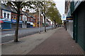
Eton Street, Hull
https://www.geograph.org.uk/photo/6823382
Image: © Ian S
Taken: 18 Apr 2021
0.02 miles
10
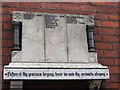
Eton Street Shrine
Many streets in Hull had these Shrines for the fallen from the First World War who did not return. More can be found here. http://www.paul-gibson.com/history/hull-in-the-first-world-war.php
Image: © Ian S
Taken: 28 Nov 2012
0.02 miles