IMAGES TAKEN NEAR TO
Norwood, BEVERLEY, HU17 9HT
Introduction
This page details the photographs taken nearby to Norwood, HU17 9HT by members of the Geograph project.
The Geograph project started in 2005 with the aim of publishing, organising and preserving representative images for every square kilometre of Great Britain, Ireland and the Isle of Man.

There are currently over 7.5m images from over14,400 individuals and you can help contribute to the project by visiting https://www.geograph.org.uk
Image Map
Images are licensed for reuse under creativecommons.org/licenses/by-sa/2.0
Notes
- Clicking on the map will re-center to the selected point.
- The higher the marker number, the further away the image location is from the centre of the postcode.
Image Listing (155 Images Found)
Images are licensed for reuse under creativecommons.org/licenses/by-sa/2.0
Image
Details
Distance
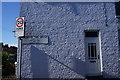
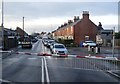
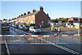
2
Bus stop on Norwood
Level crossing in the background.
Image: © JThomas
Taken: 7 Feb 2015
0.03 miles
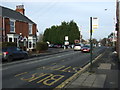
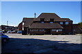
4
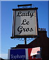
Lady Le Gros public house, Norwood, Beverley
http://www.geograph.org.uk/photo/4409117
Image: © Ian S
Taken: 27 Mar 2015
0.03 miles
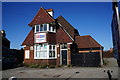
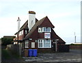
5
Lady Le Gros public house, Norwood, Beverley
http://www.geograph.org.uk/photo/4409115
Image: © Ian S
Taken: 27 Mar 2015
0.03 miles
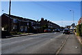
10
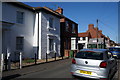
Houses on Norwood Far Grove, Norwood, Beverley
Image: © Ian S
Taken: 27 Mar 2015
0.04 miles