IMAGES TAKEN NEAR TO
Mill Lane, BEVERLEY, HU17 9AL
Introduction
This page details the photographs taken nearby to Mill Lane, HU17 9AL by members of the Geograph project.
The Geograph project started in 2005 with the aim of publishing, organising and preserving representative images for every square kilometre of Great Britain, Ireland and the Isle of Man.

There are currently over 7.5m images from over14,400 individuals and you can help contribute to the project by visiting https://www.geograph.org.uk
Image Map
Images are licensed for reuse under creativecommons.org/licenses/by-sa/2.0
Notes
- Clicking on the map will re-center to the selected point.
- The higher the marker number, the further away the image location is from the centre of the postcode.
Image Listing (280 Images Found)
Images are licensed for reuse under creativecommons.org/licenses/by-sa/2.0
Image
Details
Distance
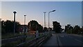
1

View from Level Crossing - Cherry Tree Lane
Image: © Betty Longbottom
Taken: 6 Sep 2016
0.01 miles
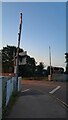
2
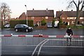
Approaching Cherry Tree Crossing
One of a number of level crossings in the town, this one crossing Cherry Tree Lane.
Image: © DS Pugh
Taken: 2 Sep 2023
0.01 miles

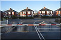
4
Cherry Tree Crossing
One of several level crossings over the railway in Beverley.
Image: © DS Pugh
Taken: 2 Sep 2023
0.02 miles
5
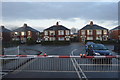
Level crossing north of Beverley Station
Image: © N Chadwick
Taken: 31 Dec 2016
0.02 miles
9

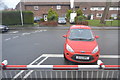
Cherry Tree Lane - viewed from Sample Avenue
Image: © Betty Longbottom
Taken: 6 Sep 2016
0.02 miles
10

View from Level Crossing - Cherry Tree Lane
Image: © Betty Longbottom
Taken: 6 Sep 2016
0.02 miles