IMAGES TAKEN NEAR TO
The Haven, BEVERLEY, HU17 8YH
Introduction
This page details the photographs taken nearby to The Haven, HU17 8YH by members of the Geograph project.
The Geograph project started in 2005 with the aim of publishing, organising and preserving representative images for every square kilometre of Great Britain, Ireland and the Isle of Man.

There are currently over 7.5m images from over14,400 individuals and you can help contribute to the project by visiting https://www.geograph.org.uk
Image Map
Images are licensed for reuse under creativecommons.org/licenses/by-sa/2.0
Notes
- Clicking on the map will re-center to the selected point.
- The higher the marker number, the further away the image location is from the centre of the postcode.
Image Listing (14 Images Found)
Images are licensed for reuse under creativecommons.org/licenses/by-sa/2.0
Image
Details
Distance

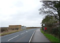
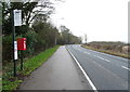
3
Lodges on Broadgate (B1230)
Showing position of Postbox No. HU17 267.
See Image] for postbox.
Image: © JThomas
Taken: 28 Dec 2019
0.17 miles
4
Broadgate (B1230)
Showing position of Postbox No. HU17 267.
See Image] for postbox.
Image: © JThomas
Taken: 28 Dec 2019
0.17 miles
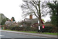
5
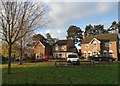
Houses in the Broadgate development near Walkington
These houses stand in what were once the grounds of a Victorian mental hospital. It was demolished in the nineteen nineties having served the citizens of East Yorkshire for over a hundred years.
Image: © Neil Theasby
Taken: 3 Dec 2014
0.18 miles
6

Elizabeth II postbox on the B1230, Broadgate
Image: © JThomas
Taken: 28 Dec 2019
0.18 miles
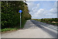
7
Bus stop on Broadgate (B1230)
Showing position of Postbox No. HU17 267.
See Image] for postbox.
Image: © JThomas
Taken: 28 Dec 2019
0.18 miles
8
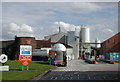
Westwood Chalk Pits, Beverley
Imerys Minerals off the southern tip of Beverley Westwood, looking southeast from the Broadgate entrance. The disused windmill, one of at least four dotted around the Westwood, may well have been used previously to crush chalk boulders in the production of whiting - the chalk powder once used in bread as well as paints and cosmetics.
Image: © Paul Glazzard
Taken: 28 Jun 2007
0.20 miles