IMAGES TAKEN NEAR TO
Ferguson Road, BEVERLEY, HU17 8SL
Introduction
This page details the photographs taken nearby to Ferguson Road, HU17 8SL by members of the Geograph project.
The Geograph project started in 2005 with the aim of publishing, organising and preserving representative images for every square kilometre of Great Britain, Ireland and the Isle of Man.

There are currently over 7.5m images from over14,400 individuals and you can help contribute to the project by visiting https://www.geograph.org.uk
Image Map
Images are licensed for reuse under creativecommons.org/licenses/by-sa/2.0
Notes
- Clicking on the map will re-center to the selected point.
- The higher the marker number, the further away the image location is from the centre of the postcode.
Image Listing (107 Images Found)
Images are licensed for reuse under creativecommons.org/licenses/by-sa/2.0
Image
Details
Distance
4
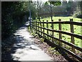
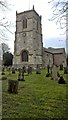
Church Walk, Walkington
Looking north, and running downhill to East End which is the main road through Walkington.
Image: © Peter Church
Taken: 6 Feb 2008
0.07 miles
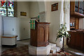
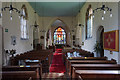
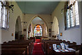
7
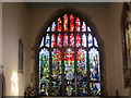
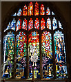
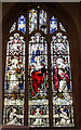
East window, All Hallows church
The glass was designed by Harry Harvey and installed in 1970.
Image: © Jonathan Thacker
Taken: 17 Oct 2014
0.07 miles