IMAGES TAKEN NEAR TO
Taylors Rise, BEVERLEY, HU17 8SF
Introduction
This page details the photographs taken nearby to Taylors Rise, HU17 8SF by members of the Geograph project.
The Geograph project started in 2005 with the aim of publishing, organising and preserving representative images for every square kilometre of Great Britain, Ireland and the Isle of Man.

There are currently over 7.5m images from over14,400 individuals and you can help contribute to the project by visiting https://www.geograph.org.uk
Image Map
Images are licensed for reuse under creativecommons.org/licenses/by-sa/2.0
Notes
- Clicking on the map will re-center to the selected point.
- The higher the marker number, the further away the image location is from the centre of the postcode.
Image Listing (110 Images Found)
Images are licensed for reuse under creativecommons.org/licenses/by-sa/2.0
Image
Details
Distance
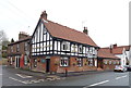
3
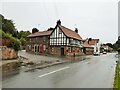
The Dog and Duck
On the B1230 road
Image: © Kevin Waterhouse
Taken: 18 Sep 2023
0.05 miles
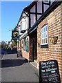
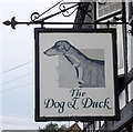
7
The Dog and Duck, Walkington
East End, the main street in Walkington, is well-provided with pubs, having three in less than 200 yards. This is the most westerly of the three.
Image: © Paul Harrop
Taken: 17 Nov 2007
0.05 miles
8
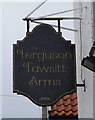
Sign for the Ferguson Fawsitt Arms, Walkington
Image: © JThomas
Taken: 28 Dec 2019
0.06 miles
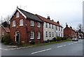
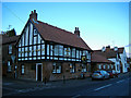
10
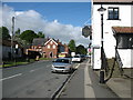
The B1230 in Walkington
A village which is clearly a commuter suburb for Beverley and Hull.
Image: © David Purchase
Taken: 10 May 2018
0.06 miles