IMAGES TAKEN NEAR TO
Lairgate, BEVERLEY, HU17 8HL
Introduction
This page details the photographs taken nearby to Lairgate, HU17 8HL by members of the Geograph project.
The Geograph project started in 2005 with the aim of publishing, organising and preserving representative images for every square kilometre of Great Britain, Ireland and the Isle of Man.

There are currently over 7.5m images from over14,400 individuals and you can help contribute to the project by visiting https://www.geograph.org.uk
Image Map
Images are licensed for reuse under creativecommons.org/licenses/by-sa/2.0
Notes
- Clicking on the map will re-center to the selected point.
- The higher the marker number, the further away the image location is from the centre of the postcode.
Image Listing (1107 Images Found)
Images are licensed for reuse under creativecommons.org/licenses/by-sa/2.0
Image
Details
Distance
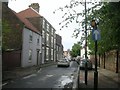
1
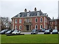
Lairgate, Beverley, Yorkshire
Lairgate Hall, built circa 1760, with later additions. The Hall was no longer needed by the East Riding of Yorkshire Council and sold in 1999 to Barnetts Office Developers. After refurbishment, the Hall has become home to prestigious offices. Grade I Listed Building https://www.historicengland.org.uk/listing/the-list/list-entry/1084022 See also: Image
Image: © Bernard Sharp
Taken: 23 Mar 2016
0.01 miles
2
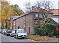
Champney Road, Beverley, Yorkshire
The 1851-2 OS map indicates that this structure was originally an outbuilding in Captain Lane, the original name of the western section of Champney Road, to the 18th century Lairgate Hall, then Beverley Hall.
Image: © Bernard Sharp
Taken: 27 Oct 2015
0.02 miles
3
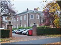
Central Avenue, Beverley, Yorkshire
Lairgate Hall, built circa 1760, with later additions. The Hall was no longer needed by the East Riding of Yorkshire Council and sold in 1999 to Barnetts Office Developers. After refurbishment, the Hall has become home to prestigious offices. The west and south-facing elevations, viewed from Central Avenue.
Grade I Listed Building https://www.historicengland.org.uk/listing/the-list/list-entry/1084022
Image: © Bernard Sharp
Taken: 3 Nov 2015
0.02 miles
4
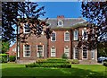
Lairgate, Beverley, Yorkshire
Lairgate Hall, built circa 1760, with later additions. The Hall was no longer needed by the East Riding of Yorkshire Council and sold in 1999 to Barnetts Office Developers. After refurbishment, the Hall has become home to prestigious offices. The south-facing elevation, viewed from Central Avenue.
Grade I Listed Building http://www.britishlistedbuildings.co.uk/en-167267-the-hall-now-borough-council-offices-bev#.VY73DpXbKUk
Image: © Bernard Sharp
Taken: 24 Jun 2015
0.02 miles
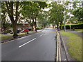
5
Lairgate - viewed from Champney Road
Image: © Betty Longbottom
Taken: 23 May 2011
0.03 miles
6
Lairgate - viewed from Champney Road
Image: © Betty Longbottom
Taken: 23 May 2011
0.03 miles
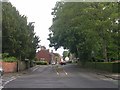
7
Admiral Walker Road - viewed from Central Avenue
Image: © Betty Longbottom
Taken: 27 Jul 2015
0.04 miles
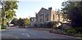
9
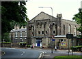
Beverley, HU17
Previously known as "The War Memorial Hall" to make explicit the rationale behind its creation, this building on Lairgate (the A164 road) is now known as "The Beverley Memorial Hall". The building was converted from a redundant church and opened "for community use" in 1959. Money, it seems, has recently become available to fund a major internal and external upgrade of the building. The town centre is 2-3 minutes walk away on the left.
Image: © David Hallam-Jones
Taken: 4 Jul 2013
0.05 miles
10
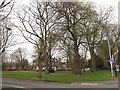
Small open space
An open space between Minster Moorgate (foreground) and Admiral Walker Road.
Image: © Stephen Craven
Taken: 21 Apr 2013
0.05 miles