IMAGES TAKEN NEAR TO
Ruston Way, BEVERLEY, HU17 8FP
Introduction
This page details the photographs taken nearby to Ruston Way, HU17 8FP by members of the Geograph project.
The Geograph project started in 2005 with the aim of publishing, organising and preserving representative images for every square kilometre of Great Britain, Ireland and the Isle of Man.

There are currently over 7.5m images from over14,400 individuals and you can help contribute to the project by visiting https://www.geograph.org.uk
Image Map
Images are licensed for reuse under creativecommons.org/licenses/by-sa/2.0
Notes
- Clicking on the map will re-center to the selected point.
- The higher the marker number, the further away the image location is from the centre of the postcode.
Image Listing (33 Images Found)
Images are licensed for reuse under creativecommons.org/licenses/by-sa/2.0
Image
Details
Distance
1
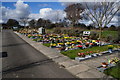
Poplars Way, Beverley
Housing and playground as seen from the footpath that runs behind the estate
Image: © Paul Harrop
Taken: 5 Jan 2008
0.03 miles
3
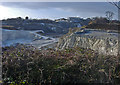
Queensgate Quarry ? eastern end
Looking west across the chalk workings
Image: © Paul Harrop
Taken: 5 Jan 2008
0.12 miles
5
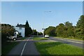
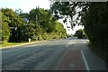
Cycle path beside Victoria Road
Heading into Beverley from the south west side.
Image: © DS Pugh
Taken: 2 Sep 2023
0.13 miles
8
Victoria Road near Poplars Way
A cycle path runs alongside Victoria Road.
Image: © DS Pugh
Taken: 2 Sep 2023
0.15 miles