IMAGES TAKEN NEAR TO
Blossom Close, BEVERLEY, HU17 7SW
Introduction
This page details the photographs taken nearby to Blossom Close, HU17 7SW by members of the Geograph project.
The Geograph project started in 2005 with the aim of publishing, organising and preserving representative images for every square kilometre of Great Britain, Ireland and the Isle of Man.

There are currently over 7.5m images from over14,400 individuals and you can help contribute to the project by visiting https://www.geograph.org.uk
Image Map
Images are licensed for reuse under creativecommons.org/licenses/by-sa/2.0
Notes
- Clicking on the map will re-center to the selected point.
- The higher the marker number, the further away the image location is from the centre of the postcode.
Image Listing (62 Images Found)
Images are licensed for reuse under creativecommons.org/licenses/by-sa/2.0
Image
Details
Distance
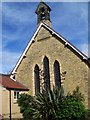
2
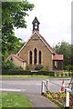
St Leonard's Church, Molescroft
Well-known for its warm welcome and its singing St. Leonard’s is a very active church.
Image: © Maigheach-gheal
Taken: 12 Oct 2007
0.08 miles
3
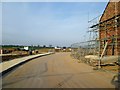
Another field lost to houses
Molescroft creeps out into the countryside, behind this estate they are building another section of by pass from Driffield Road to Malton Road
Image: © Martin Dawes
Taken: 29 Aug 2016
0.09 miles
4
Elm Tree Park
A new development in Molescroft. Of course there is no evidence of any elms or a park though much of the estate is built on the site of Elm Tree Farm. Hailstorm fast approaching.
Image: © Jonathan Thacker
Taken: 5 Mar 2016
0.09 miles
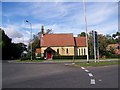
5
St Leonard's Church, Molescroft
Rather small, but well-used.
Image: © Carolyn Metcalf
Taken: 16 Jun 2005
0.09 miles
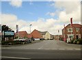
6
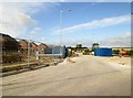
New housing development off Malton Road Molescroft
Image: © Martin Dawes
Taken: 22 Mar 2015
0.09 miles
7
New houses new section of Beverley bypass
This section of bypass is between Driffield Road and Malton Road, at this end the roundabout has had to be altered and moved, on Malton Road they are building a new roundabout. The houses on the new estate have been built right down the field to the road.
Image: © Martin Dawes
Taken: 29 Sep 2016
0.10 miles
8
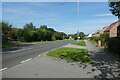
Cycle path beside Malton Road
National Cycle Network routes 1 and 66 run along here.
Image: © DS Pugh
Taken: 3 Sep 2023
0.11 miles
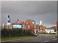
9

Malton Road, Molescroft
The houses arrived in 2015, while the road has been downgraded since then and the green sign replaced by a minor road white one (although for reasons only known to the Department of Transport this includes much of the A4). You get to learn this travelling around the country and as well as the downgrading some of the road numbering makes no sense at all, in particular the A5 and 6 north of London.
Image: © David Howard
Taken: 6 Aug 2019
0.11 miles
10
Elm Tree Park on Malton Road
The estate which spreads between here and the nearby bypass was built in 2015
Image: © David Howard
Taken: 6 Aug 2019
0.11 miles