IMAGES TAKEN NEAR TO
South Dalton, BEVERLEY, HU17 7PX
Introduction
This page details the photographs taken nearby to HU17 7PX by members of the Geograph project.
The Geograph project started in 2005 with the aim of publishing, organising and preserving representative images for every square kilometre of Great Britain, Ireland and the Isle of Man.

There are currently over 7.5m images from over14,400 individuals and you can help contribute to the project by visiting https://www.geograph.org.uk
Image Map
Images are licensed for reuse under creativecommons.org/licenses/by-sa/2.0
Notes
- Clicking on the map will re-center to the selected point.
- The higher the marker number, the further away the image location is from the centre of the postcode.
Image Listing (9 Images Found)
Images are licensed for reuse under creativecommons.org/licenses/by-sa/2.0
Image
Details
Distance
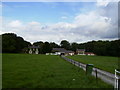
2
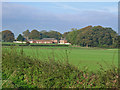
Holme Wold House
Looking NW from the road to the farm on the west edge of the grid square.
Image: © Stephen Horncastle
Taken: 30 Oct 2006
0.04 miles
4
Minor road from Holme on the Wolds
Holme Wold House Farm to the right in the trees
Image: © Martin Dawes
Taken: 16 May 2014
0.10 miles
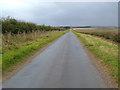
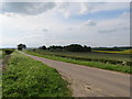
5

Very straight typical Wolds road near Home Wold House
Image: © Phil Catterall
Taken: 2 Oct 2006
0.11 miles