IMAGES TAKEN NEAR TO
Dalton Park, BEVERLEY, HU17 7PS
Introduction
This page details the photographs taken nearby to Dalton Park, HU17 7PS by members of the Geograph project.
The Geograph project started in 2005 with the aim of publishing, organising and preserving representative images for every square kilometre of Great Britain, Ireland and the Isle of Man.

There are currently over 7.5m images from over14,400 individuals and you can help contribute to the project by visiting https://www.geograph.org.uk
Image Map
Images are licensed for reuse under creativecommons.org/licenses/by-sa/2.0
Notes
- Clicking on the map will re-center to the selected point.
- The higher the marker number, the further away the image location is from the centre of the postcode.
Image Listing (8 Images Found)
Images are licensed for reuse under creativecommons.org/licenses/by-sa/2.0
Image
Details
Distance
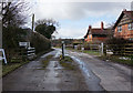
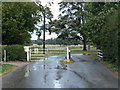
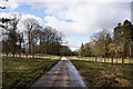
3
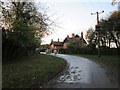
Western exit to Dalton Park
From Park Road it becomes Park Lane beyond the gate and cattle grid. Estate cottages to the right the farm is behind the hedge on the left.
Image: © Martin Dawes
Taken: 12 Nov 2014
0.02 miles
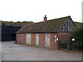
7
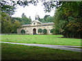
Stables at South Dalton Hall
They might have very posh stables but the clock doesn't work this photo was taken at 11:40am.
Image: © Ian Lavender
Taken: 3 Oct 2005
0.18 miles
