IMAGES TAKEN NEAR TO
Chapel Garth, BEVERLEY, HU17 7NS
Introduction
This page details the photographs taken nearby to Chapel Garth, HU17 7NS by members of the Geograph project.
The Geograph project started in 2005 with the aim of publishing, organising and preserving representative images for every square kilometre of Great Britain, Ireland and the Isle of Man.

There are currently over 7.5m images from over14,400 individuals and you can help contribute to the project by visiting https://www.geograph.org.uk
Image Map
Images are licensed for reuse under creativecommons.org/licenses/by-sa/2.0
Notes
- Clicking on the map will re-center to the selected point.
- The higher the marker number, the further away the image location is from the centre of the postcode.
Image Listing (96 Images Found)
Images are licensed for reuse under creativecommons.org/licenses/by-sa/2.0
Image
Details
Distance
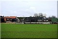
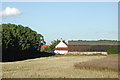
4
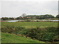
View towards Arram
Looking acriss the Catchwater Drain and a large pond.
Image: © Jonathan Thacker
Taken: 16 Oct 2015
0.03 miles
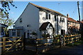
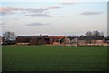
6
Riding Hill Farm, Arram
Looking east from where the Beverley to Driffield railway line crosses Catchwater Drain at Arram Station.
Image: © Paul Glazzard
Taken: 10 Aug 2008
0.03 miles
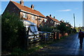
7
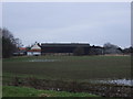
Riding Hill Farm
From Arram Railway Station.
Image: © JThomas
Taken: 7 Feb 2015
0.04 miles